
TDS. Thats down. Unreal…Madness.
View attachment 26956
Navigation
Install the app
How to install the app on iOS
Follow along with the video below to see how to install our site as a web app on your home screen.
Note: This feature may not be available in some browsers.
More options
-
Welcome to TalkWeather! We see you lurking around TalkWeather! Take the extra step and join us today to view attachments, see less ads and maybe even join the discussion. CLICK TO JOIN TALKWEATHER
You are using an out of date browser. It may not display this or other websites correctly.
You should upgrade or use an alternative browser.
You should upgrade or use an alternative browser.
Severe Weather Threat May 7-10, 2024
- Thread starter MichelleH
- Start date
- Messages
- 751
- Reaction score
- 2,465
- Location
- Mississippi State University
- Special Affiliations
- SKYWARN® Volunteer
Man how unlucky can Henagar get.
TornadoFan
Member
Oh god, make it stop.
Evan
Member
I cannot believe this. Appears to be right on top of one of the earlier areas that had entrapments.
tennessee storm chaser
Member
- Messages
- 1,877
- Reaction score
- 4,283
- Location
- jackson tennessee
- Special Affiliations
- SKYWARN® Volunteer
Storm heading towards Memphis getting some inflow …. Got my eye on it
MattW
Member
- Messages
- 388
- Reaction score
- 382
- Location
- Decatur, GA
- HAM Callsign
- KG4GUF
- Special Affiliations
- SKYWARN® Volunteer
Side note, what radar are you using? GR2A? I don't quite recognize those displays/products.Madness.
*pic removed for brevity*
brianc33710
Member
I guess we will wait & see what happens with that the storms that come thru early am & then the pm. These have overperformed & the SPC already increased Cen AL to 3/5. Hopefully the trend reverses & we don't see SPC give us a 4/5 for Thu night/Fri am.
- Messages
- 751
- Reaction score
- 2,465
- Location
- Mississippi State University
- Special Affiliations
- SKYWARN® Volunteer
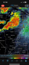
That's correct, GR2A. I cooked up custom color palettes for velocity and reflectivity because the pre-existing colors hurt my eyes, especially against the landsat background.Side note, what radar are you using? GR2A? I don't quite recognize those displays/products.
Evan
Member
The entire time my family lived near Sand Mountain this was just common. Rotating storms get there and then that's when they produce. The amount of Sand Mountain tornadoes is just unbelievable. There's got to be a study on this because it is uncanny how often it happens.
MattW
Member
- Messages
- 388
- Reaction score
- 382
- Location
- Decatur, GA
- HAM Callsign
- KG4GUF
- Special Affiliations
- SKYWARN® Volunteer
I was wondering about that too. I wonder if it has something to do with the river, then the mountain. Some kind of upslope effect.The entire time my family lived near Sand Mountain this was just common. Rotating storms get there and then that's when they produce. The amount of Sand Mountain tornadoes is just unbelievable. There's got to be a study on this because it is uncanny how often it happens.
Legitimately dizzy now from all of this, and am probably going to try and get some shut eye. But I leave you with this; Alabama and Georgia folks, do not let your guard down as the additional storms currently out west move in. Modelling has been consistent in presenting a very potent line of storms moving in late late tonight into the morning hours. If today was any indicator, it'd be unwise to turn your back on these.

Evan
Member
I was wondering about that too. I wonder if it has something to do with the river, then the mountain. Some kind of upslope effect.
I know Tim Coleman at UAH specifically studied the influence of Sand Mountain and the interaction of slopes, valleys, and ridges. Two of his test cases were two of the 2011 Sand Mountain tornadoes. But I think that was years ago and I'm thinking more macro level such as mapping out how many tornados occur on Sand Mountain overall versus areas nearby with dissimilar terrain. It's fascinating for sure!
Tony Lyza did a sizable portion of his PhD dissertation on this.The entire time my family lived near Sand Mountain this was just common. Rotating storms get there and then that's when they produce. The amount of Sand Mountain tornadoes is just unbelievable. There's got to be a study on this because it is uncanny how often it happens.
NorthGaWeather
Member
Here is their study.Tony Lyza did a sizable portion of his PhD dissertation on this.
Shakespeare 2016
Member
He was the guy who said that Tim Marshall is incahoots with State Farm because of the abysmally underrated Westminister, TX tornado which happened exactly 18 years ago to the day.Tony Lyza did a sizable portion of his PhD dissertation on this.
That was on the old American WX thread.
Evan
Member
Andy and NorthGaWeather, thank you for that. That will be my bedtime reading as I finally do go to bed.
Evan
Member
Henager FD reporting a serious injury with head trauma and damage to the extremities.
Henager continues to call for additional mutual aid. Now calling in all Ider and Cartersville Fire. Few moments ago they called in Blake FD.
I'm very concerned about what daylight is going to reveal.
Henager continues to call for additional mutual aid. Now calling in all Ider and Cartersville Fire. Few moments ago they called in Blake FD.
I'm very concerned about what daylight is going to reveal.
Kds86z
Member
Man..Henager FD reporting a serious injury with head trauma and damage to the extremities.
Henager continues to call for additional mutual aid. Now calling in all Ider and Cartersville Fire. Few moments ago they called in Blake FD.
I'm very concerned about what daylight is going to reveal.