TornadoFan
Member
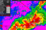
Looks like new storms forming south of Clinton.
Follow along with the video below to see how to install our site as a web app on your home screen.
Note: This feature may not be available in some browsers.
Just...don't...the high risk timeline was always after dark. It has yet to get in its prime.Biggest threat right now appears to be flash flooding. The high risk verification might come down to the tail end Charlie headed for okc.
Yup. Was thinking same. April 27 was quiet before hell let looseJust...don't...the high risk timeline was always after dark. It has yet to get in its prime.
Any better viewing option for that cell than KTLX and KVNX? It's just a pinch too far away from both to get a good look.Yikes, that Custer City cell is going nuts. Likely going to be a big problem here shortly.
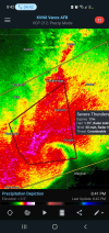
Storm near Marshall, Oklahoma has BTI of 9.1!
We’re not even into the main show yet either.Yup. Was thinking same. April 27 was quiet before hell let loose
Baron Tornado IndexWhat's BTI?
I think it's Baron Tornado Index, or something like that. It's a proprietary index by Baron technologies to forecast likelihood of tornado.What's BTI?
Thank you.I think it's Baron Tornado Index, or something like that. It's a proprietary index by Baron technologies to forecast likelihood of tornado.
Baron Tornado Index. It is Baron's tornado ranking algorithm that takes environmental data and combines it with radar data (but weighs heavier on the environmental data for the calculation) and does a ranking of 0-10 of the likelihood of the storm to produce a tornado. Higher values naturally have a higher chance, but storms that have a BTI that quickly trends upward with time over a few radar scans and/or have a higher BTI than the other storms surrounding them are storms to pay close attention to. The 9.1 there is more driven by the parameter space than it is radar suggesting there's a violent tornado down. On the same token, in the cool season when instability is lower, you can frequently get EF2-EF4 tornadoes with a BTI as low as a 4-5.What's BTI?