PDS Tornado Watch is out with >95%/90% TOR probs.
Navigation
Install the app
How to install the app on iOS
Follow along with the video below to see how to install our site as a web app on your home screen.
Note: This feature may not be available in some browsers.
More options
-
Welcome to TalkWeather! We see you lurking around TalkWeather! Take the extra step and join us today to view attachments, see less ads and maybe even join the discussion. CLICK TO JOIN TALKWEATHER
You are using an out of date browser. It may not display this or other websites correctly.
You should upgrade or use an alternative browser.
You should upgrade or use an alternative browser.
Severe Weather Threat - May 6, 2024
- Thread starter KevinH
- Start date
TH2002
Member
- Messages
- 4,974
- Reaction score
- 11,116
- Location
- California, United States
- Special Affiliations
- SKYWARN® Volunteer
Already another cell popping over Bucklin, KS.
SmokeEater
Member
Jesus the wording...
Equus
Member
90/95 probs PDS out
- Moderator
- #565
Yes! The wording being used is giving me flashbacks! (Again please don’t think I’m comparing)
I understand. When I saw that statement it's the first thing I thought of.
TornadoFan
Member
cincywx
Member
behind-the-scenes!
That's correct. There's also a little bit of VBV in there, but yeah, real life hodos will always look less smooth than forecasted ones.I assume the hodograph having a "squiggly" nature like that is the product of an actual weather balloon launch versus a forecast?
- Thread starter
- #569
KevinH
Member
95/90 probs 

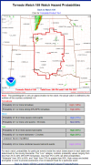
URGENT - IMMEDIATE BROADCAST REQUESTED
Tornado Watch Number 189
NWS Storm Prediction Center Norman OK
200 PM CDT Mon May 6 2024
The NWS Storm Prediction Center has issued a
* Tornado Watch for portions of
Southern Kansas
Western and Central Oklahoma
Western North Texas
* Effective this Monday afternoon and evening from 200 PM until 1100 PM CDT.
...THIS IS A PARTICULARLY DANGEROUS SITUATION...
* Primary threats include...
-Numerous tornadoes expected with a few intense tornadoes likely.
-Widespread large hail and scattered very large hail events to 4 inches in diameter likely.
-Scattered damaging winds and isolated significant gusts to 75 mph likely.
SUMMARY...
Explosive thunderstorm development is forecast this afternoon along and east of a north to south oriented dryline.
Given a very favorable environment for severe thunderstorms, intense supercells are expected to evolve. These storms are forecast to move east across the Watch area this afternoon through the late evening.
The possibility exists for regenerative supercell development over central Oklahoma this evening. Initially large to giant hail is forecast with the initial supercell activity before the tornado risk increases. Intense tornadoes are probable especially as the atmosphere becomes very favorable for tornadoes late this afternoon and continuing through the evening.
The tornado watch area is approximately along and 105 statute miles east and west of a line from 25 miles north northwest of HutchinsonKS to 50 miles south southeast of Fort Sill OK.
Storm Prediction Center PDS Tornado Watch 189
Severe weather, tornado, thunderstorm, fire weather, storm report, tornado watch, severe thunderstorm watch, mesoscale discussion, convective outlook products from the Storm Prediction Center.
www.spc.noaa.gov
URGENT - IMMEDIATE BROADCAST REQUESTED
Tornado Watch Number 189
NWS Storm Prediction Center Norman OK
200 PM CDT Mon May 6 2024
The NWS Storm Prediction Center has issued a
* Tornado Watch for portions of
Southern Kansas
Western and Central Oklahoma
Western North Texas
* Effective this Monday afternoon and evening from 200 PM until 1100 PM CDT.
...THIS IS A PARTICULARLY DANGEROUS SITUATION...
* Primary threats include...
-Numerous tornadoes expected with a few intense tornadoes likely.
-Widespread large hail and scattered very large hail events to 4 inches in diameter likely.
-Scattered damaging winds and isolated significant gusts to 75 mph likely.
SUMMARY...
Explosive thunderstorm development is forecast this afternoon along and east of a north to south oriented dryline.
Given a very favorable environment for severe thunderstorms, intense supercells are expected to evolve. These storms are forecast to move east across the Watch area this afternoon through the late evening.
The possibility exists for regenerative supercell development over central Oklahoma this evening. Initially large to giant hail is forecast with the initial supercell activity before the tornado risk increases. Intense tornadoes are probable especially as the atmosphere becomes very favorable for tornadoes late this afternoon and continuing through the evening.
The tornado watch area is approximately along and 105 statute miles east and west of a line from 25 miles north northwest of HutchinsonKS to 50 miles south southeast of Fort Sill OK.
Last edited:
Tempestas Tonitrua
Member
My goodness. When is the last time it was 90/95%? 5/20/19?
cincywx
Member
URGENT - IMMEDIATE BROADCAST REQUESTED
TORNADO WATCH NUMBER 189
NWS STORM PREDICTION CENTER NORMAN OK
200 PM CDT MON MAY 6 2024
THE NWS STORM PREDICTION CENTER HAS ISSUED A
* TORNADO WATCH FOR PORTIONS OF
SOUTHERN KANSAS
WESTERN AND CENTRAL OKLAHOMA
WESTERN NORTH TEXAS
* EFFECTIVE THIS MONDAY AFTERNOON AND EVENING FROM 200 PM UNTIL
1100 PM CDT.
..THIS IS A PARTICULARLY DANGEROUS SITUATION
* PRIMARY THREATS INCLUDE...
NUMEROUS TORNADOES EXPECTED WITH A FEW INTENSE TORNADOES LIKELY
WIDESPREAD LARGE HAIL AND SCATTERED VERY LARGE HAIL EVENTS TO 4
INCHES IN DIAMETER LIKELY
SCATTERED DAMAGING WINDS AND ISOLATED SIGNIFICANT GUSTS TO 75
MPH LIKELY
SUMMARY...EXPLOSIVE THUNDERSTORM DEVELOPMENT IS FORECAST THIS
AFTERNOON ALONG AND EAST OF A NORTH TO SOUTH ORIENTED DRYLINE.
GIVEN A VERY FAVORABLE ENVIRONMENT FOR SEVERE THUNDERSTORMS, INTENSE
SUPERCELLS ARE EXPECTED TO EVOLVE. THESE STORMS ARE FORECAST TO
MOVE EAST ACROSS THE WATCH AREA THIS AFTERNOON THROUGH THE LATE
EVENING. THE POSSIBILITY EXISTS FOR REGENERATIVE SUPERCELL
DEVELOPMENT OVER CENTRAL OKLAHOMA THIS EVENING. INITIALLY LARGE TO
GIANT HAIL IS FORECAST WITH THE INITIAL SUPERCELL ACTIVITY BEFORE
THE TORNADO RISK INCREASES. INTENSE TORNADOES ARE PROBABLE
ESPECIALLY AS THE ATMOSPHERE BECOMES VERY FAVORABLE FOR TORNADOES
LATE THIS AFTERNOON AND CONTINUING THROUGH THE EVENING.
My goodness, that summary.
URGENT - IMMEDIATE BROADCAST REQUESTED
Tornado Watch Number 189
NWS Storm Prediction Center Norman OK
200 PM CDT Mon May 6 2024
The NWS Storm Prediction Center has issued a
* Tornado Watch for portions of
Southern Kansas
Western and Central Oklahoma
Western North Texas
* Effective this Monday afternoon and evening from 200 PM until
1100 PM CDT.
...THIS IS A PARTICULARLY DANGEROUS SITUATION...
* Primary threats include...
Numerous tornadoes expected with a few intense tornadoes likely
Widespread large hail and scattered very large hail events to 4
inches in diameter likely
Scattered damaging winds and isolated significant gusts to 75
mph likely
SUMMARY...Explosive thunderstorm development is forecast this
afternoon along and east of a north to south oriented dryline.
Given a very favorable environment for severe thunderstorms, intense
supercells are expected to evolve. These storms are forecast to
move east across the Watch area this afternoon through the late
evening. The possibility exists for regenerative supercell
development over central Oklahoma this evening. Initially large to
giant hail is forecast with the initial supercell activity before
the tornado risk increases. Intense tornadoes are probable
especially as the atmosphere becomes very favorable for tornadoes
late this afternoon and continuing through the evening.
The tornado watch area is approximately along and 105 statute miles
east and west of a line from 25 miles north northwest of Hutchinson
KS to 50 miles south southeast of Fort Sill OK. For a complete
depiction of the watch see the associated watch outline update
(WOUS64 KWNS WOU9).
southmdwatcher
Member
The last time I saw wording this strong was on that infamous late April day in 2011.
Kds86z
Member
“Regenerative supercell development” = training cells?
OHWX97
Member
Wasn't it 95/95% on May 20th?My goodness. When is the last time it was 90/95%? 5/20/19?
Edit: Just looked it up. This is NOT current. This is the PDS tornado watch on 5/20/2019 with maxed out probabilities all across the board.
TORNADO WATCH PROBABILITIES FOR WT 0199
NWS STORM PREDICTION CENTER NORMAN OK
0132 PM CDT MON MAY 20 2019
WT 0199 PDS
PROBABILITY TABLE:
PROB OF 2 OR MORE TORNADOES : >95%
PROB OF 1 OR MORE STRONG /EF2-EF5/ TORNADOES : >95%
PROB OF 10 OR MORE SEVERE WIND EVENTS : >95%
PROB OF 1 OR MORE WIND EVENTS >= 65 KNOTS : >95%
PROB OF 10 OR MORE SEVERE HAIL EVENTS : >95%
PROB OF 1 OR MORE HAIL EVENTS >= 2 INCHES : >95%
PROB OF 6 OR MORE COMBINED SEVERE HAIL/WIND EVENTS : >95%
&&
ATTRIBUTE TABLE:
MAX HAIL /INCHES/ : 4.0
MAX WIND GUSTS SURFACE /KNOTS/ : 70
MAX TOPS /X 100 FEET/ : 600
MEAN STORM MOTION VECTOR /DEGREES AND KNOTS/ : 23035
PARTICULARLY DANGEROUS SITUATION : YES
&&
FOR A COMPLETE GEOGRAPHICAL DEPICTION OF THE WATCH AND
WATCH EXPIRATION INFORMATION SEE WOUS64 FOR WOU9.
$$
Last edited:
cincywx
Member
My goodness. When is the last time it was 90/95%? 5/20/19?
I believe one of the PDS watches on 3/31/23 was also 95/90
jiharris0220
Member
Feels like a full blown sauna out here.
This is the kind of environment that even if there are clouds, it wouldn’t matter.
This is the kind of environment that even if there are clouds, it wouldn’t matter.
TornadoFan
Member
TH2002
Member
- Messages
- 4,974
- Reaction score
- 11,116
- Location
- California, United States
- Special Affiliations
- SKYWARN® Volunteer
I don't have an account on birdsite, but I can imagine there's already a fair amount of bust-posting going on over there...