
Navigation
Install the app
How to install the app on iOS
Follow along with the video below to see how to install our site as a web app on your home screen.
Note: This feature may not be available in some browsers.
More options
-
Welcome to TalkWeather! We see you lurking around TalkWeather! Take the extra step and join us today to view attachments, see less ads and maybe even join the discussion. CLICK TO JOIN TALKWEATHER
You are using an out of date browser. It may not display this or other websites correctly.
You should upgrade or use an alternative browser.
You should upgrade or use an alternative browser.
Severe Weather Threat - May 6, 2024
- Thread starter KevinH
- Start date
Casuarina Head
Member
Did CAMs originally forecast the erosion of the cap over southern KS by 18Z today, or is this ahead of schedule?
TornadoFan
Member

TH2002
Member
- Messages
- 4,974
- Reaction score
- 11,116
- Location
- California, United States
- Special Affiliations
- SKYWARN® Volunteer
If I lived in Oklahoma right now:
SmokeEater
Member
From OUN: Something interesting to note on storm mode: HRRR/RAP bulk shear vectors (0-6km) are predominantly perpendicular to the dryline into the evening for areas generally along/south of I-40 with vectors more parallel across northern Oklahoma. This would favor more of a linear storm mode up north and discrete mode across central.
Tanner
Member
aujerm
Member
I assume the hodograph having a "squiggly" nature like that is the product of an actual weather balloon launch versus a forecast?
TornadoFan
Member
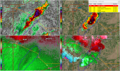
Already severe warned.This cell just blew up within the last few radar scans in southern Kansas...here we go.
Casuarina Head
Member
North of I-40 would cover most, or at least more than half, of the HIGH-Risk area. I though discrete mode was originally favoured in north-central OK? At the very least, the northern extent of the 30% will need to be trimmed.From OUN: Something interesting to note on storm mode: HRRR/RAP bulk shear vectors (0-6km) are predominantly perpendicular to the dryline into the evening for areas generally along/south of I-40 with vectors more parallel across northern Oklahoma. This would favor more of a linear storm mode up north and discrete mode across central.
atrainguy
Member
Already a tornado warning near the northern limit of the marginal zone and cells rapidly popping up in Kansas - foreshadowing for later?
SmokeEater
Member
TOG SD.
cincywx
Member
TOG SD.
...A TORNADO WARNING REMAINS IN EFFECT UNTIL 115 PM MDT FOR
SOUTHEASTERN HARDING AND NORTHEASTERN BUTTE COUNTIES...
At 1256 PM MDT, a confirmed tornado was located 5 miles east of Dears
Ears Butte, or 44 miles northeast of Belle Fourche, moving north at
30 mph.
HAZARD...Damaging tornado.
SOURCE...Weather spotters confirmed tornado.
SmokeEater
Member
Whopping 82 people live in the warning.TOG SD.
TornadoFan
Member
SmokeEater
Member
PDS watch about to be issued for most of OUN CWA until 11pm.
southmdwatcher
Member
PDS Tornado Watch is officially issued now....2pm to 11pm CDT