
Navigation
Install the app
How to install the app on iOS
Follow along with the video below to see how to install our site as a web app on your home screen.
Note: This feature may not be available in some browsers.
More options
-
Welcome to TalkWeather! We see you lurking around TalkWeather! Take the extra step and join us today to view attachments, see less ads and maybe even join the discussion. CLICK TO JOIN TALKWEATHER
You are using an out of date browser. It may not display this or other websites correctly.
You should upgrade or use an alternative browser.
You should upgrade or use an alternative browser.

This guy just cruising along all by himself


Live Streaming Channels - Tennessee Valley Weather
TENNESSEE VALLEY WEATHER CHANNEL WATCH AND SUBSCRIBE @TENNESSEEVALLEYWEATHER YOUTUBE FEED LOCAL SERVER FEED DOPPLER RADAR LIVE STREAM PRESENTED BY C&B LINEN YOUTUBE FEED LOCAL SERVER FEED
 tnvalleyweather.com
One thing that stands out to me right now is the lack of junk convection.
Good to see you on here again Richard! Hope you’re doing wellOne thing that stands out to me right now is the lack of junk convection.
Mundiejc
Member
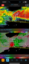
The weirdest discombobulated convections are producing Mesos and the organized cells aren’t. Very strange. The storm near Jackson tn makes no sense to me
TOG near Jackson, TN.

Severe Weather Statement
National Weather Service Memphis TN
324 PM CDT Tue May 20 2025
TNC017-053-077-113-202100-
/O.CON.KMEG.TO.W.0145.000000T0000Z-250520T2100Z/
Henderson TN-Gibson TN-Carroll TN-Madison TN-
324 PM CDT Tue May 20 2025
...A TORNADO WARNING REMAINS IN EFFECT UNTIL 400 PM CDT FOR
NORTHWESTERN HENDERSON...SOUTHEASTERN GIBSON...SOUTHWESTERN CARROLL
AND NORTHERN MADISON COUNTIES...
At 323 PM CDT, a confirmed tornado was located over Jackson, moving
northeast at 35 mph.
HAZARD...Damaging tornado and quarter size hail.
SOURCE...Weather spotters confirmed tornado.
IMPACT...Flying debris will be dangerous to those caught without
shelter. Mobile homes will be damaged or destroyed. Damage
to roofs, windows, and vehicles will occur. Tree damage is
likely.
Locations impacted include...
Three Way, Neely, Bemis, Cedar Grove, Huntersville, Jackson,
Westover, Juno, Fairview, Gilmore, Medina, Blue Goose, Sitka, East
Union, Claybrook, Adair, Youngs Crossing, West, Windy City, and
Lavinia.
PRECAUTIONARY/PREPAREDNESS ACTIONS...
To repeat, a tornado is on the ground. TAKE COVER NOW! Move to a
storm shelter or an interior room on the lowest floor of a sturdy
building. Avoid windows. If you are outdoors, in a mobile home, or in
a vehicle, move to the closest substantial shelter and protect
yourself from flying debris.
&&
LAT...LON 3552 8894 3565 8900 3570 8899 3575 8894
3592 8868 3566 8846
TIME...MOT...LOC 2023Z 239DEG 29KT 3564 8888
TORNADO...OBSERVED
MAX HAIL SIZE...1.00 IN
$$
AEH
Kds86z
Member
Dang that’s tiny lol
Ryan Hall has a good look on his stream
These types of days can be dangerous, especially come after dark. I’ve been talking to @UncleJuJu98 about how much this event reminds me so much of 5/8/2024 last year so far.
TornadoFan
Member

Jackson, TN
@tennessee storm chaser its right on your doorstep man
Justin Hindman
Member
- Messages
- 378
- Reaction score
- 1,165
- Location
- Gardendale Alabama
- Special Affiliations
- SKYWARN® Volunteer
- ARRL Member
cheestaysfly
Member
Well I'm having a bad time - I have an underground storm shelter but I can't get the shelter door to close! That's like, the absolute opposite of what I need it to do lol. Hopefully I won't need to use it today.


kcyalater
Member
bruh we’ve got tornado showers out here and fully matured supercells gatekeeping.
Kds86z
Member
Equus
Member
86/73 in Jasper right now. Most sites reporting southwest winds but that's not really hindering at least a handful of supercells. Sustaining strong enough low level mesos or not to drop more than a few tornadoes with pretty minimal low level directional shear, we shall see

kcyalater
Member
the storm south of dumas AR has an absolutely spectacular structure.