
Lol it's never a severe weather forum unless there's some of this lol, I've learned to just ignore it lol.Here we go, petulant. It’s started early today.
Navigation
Install the app
How to install the app on iOS
Follow along with the video below to see how to install our site as a web app on your home screen.
Note: This feature may not be available in some browsers.
More options
-
Welcome to TalkWeather! We see you lurking around TalkWeather! Take the extra step and join us today to view attachments, see less ads and maybe even join the discussion. CLICK TO JOIN TALKWEATHER
You are using an out of date browser. It may not display this or other websites correctly.
You should upgrade or use an alternative browser.
You should upgrade or use an alternative browser.
N4GK
Member
- Messages
- 97
- Reaction score
- 214
- Location
- Meridianville, Al.
- HAM Callsign
- N4GKS
- Special Affiliations
- ARRL Member
Let’s just act like adults today for a change.So what do you propose I do? Just take the disrespect and him putting words in my mouth that I did not say?
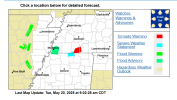
Latest D1 expanded the Enhanced for wind.

SPC AC 201239
Day 1 Convective Outlook
NWS Storm Prediction Center Norman OK
0739 AM CDT Tue May 20 2025
Valid 201300Z - 211200Z
...THERE IS AN ENHANCED RISK OF SEVERE THUNDERSTORMS MID/DEEP SOUTH
TO TN VALLEY AND CUMBERLAND PLATEAU...
...SUMMARY...
Multiple rounds of severe thunderstorms are expected today through
this evening, centered on the Mid/Deep South, Tennessee/Lower Ohio
Valleys, and Cumberland Plateau. Tornadoes, some of which could be
strong, along with scattered to widespread damaging winds, and large
to isolated significant severe hail will be possible.
...Mid/Deep South to the TN/Lower OH Valleys and Cumberland
Plateau...
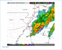
Water-vapor imagery this morning shows a negatively tilted,
large-scale mid to upper-level trough centered over the Dakotas
southeastward through the mid MS Valley and Ozarks. Several
thunderstorms clusters are ongoing within a larger corridor of
convection from the OH Valley southwestward into the lower MS
Valley. This activity is occurring to the east/southeast of a
gradually filling cyclone forecast to move from the lower MO Valley
eastward into the southwest Great Lakes by late tonight.
Little change was made to the previous outlook due in part to
general consistency in model guidance and observational trends noted
this morning. Richer low-level moisture from west-central KY
southward into the Gulf Coast states will contribute to a moderate
to very unstable airmass by the early afternoon in areas void of
recent convective outflow and associated cloud debris. Scattered to
numerous thunderstorms are forecast to develop coincident with the
diurnal heating cycle. Forecast hodographs coupled with progged
buoyancy will support a mix of supercells and line segments this
afternoon. The initial supercell activity will potentially yield a
threat for large to very large hail. It appears the greatest risk
for supercell tornadoes may exist from northern MS
east-northeastward into middle TN. Morning convection and
associated destabilization concerns preclude higher tornado risk
probabilities. However, models continue to indicate upscale growth
into several bands will occur late this afternoon through the late
evening as storms move east across the Enhanced (level 3) Risk area.
Have enlarged severe/damaging wind probabilities across AL/GA to
account for confidence in a continuation of a wind threat persisting
through the evening.
...IL/IN...
Within the left-exit region of a cyclonically curved mid to upper
speed max, a dry slot and attendant corridor of steep lapse rates
will likely evolve across portions of MO to IL/IN from midday into
the afternoon. Destabilization will likely be less across the mid
MS Valley eastward into IN, with the richer moisture confined south
of residual outflow and warm frontal zone over the lower OH Valley.
Nonetheless, isolated to scattered severe thunderstorms are possible
later today into the evening via a mix of shorter-lived supercells
and organized multicells. Isolated to scattered coverage of severe
and all hazards are possible with the stronger storms before this
activity diminishes during the evening.
..Smith/Marsh.. 05/20/2025
N4GK
Member
- Messages
- 97
- Reaction score
- 214
- Location
- Meridianville, Al.
- HAM Callsign
- N4GKS
- Special Affiliations
- ARRL Member
Well, it’s rare they change it from one to another, but anything is possible.
12z hrrr again has some decent supercells in north Alabama.
N4GK
Member
- Messages
- 97
- Reaction score
- 214
- Location
- Meridianville, Al.
- HAM Callsign
- N4GKS
- Special Affiliations
- ARRL Member
That’s the talk. First, the super cells come in, then the high winds at an enormous pace. And this time, the rain‘s not gonna save us ahead of time, and cool everything off before hand.12z hrrr again has some decent supercells in The super sales, then the.
I'm wondering if this sun that's out will increase those lapse rates. For any of those supecells.That’s the talk. First, the super cells come in, then the high winds at an enormous pace. And this time, the rain‘s not gonna save us ahead of time, and cool everything off before hand.
zath
Member
Weak to modest lapse rates, weak directional shear, modest speed shear, messy storm mode, decent CAPE if we get some breaks in the clouds... it makes sense to me the lack of higher probabilities from the SPC. There is probably going to be a small window along and east of the Mississippi River in eastern AR across northern MS and southwestern TN where storms could interact with any outflow boundaries left over from the morning showers/storms that may enhance tornado potential, but otherwise looks mostly like a wind risk, especially if the storms quickly grow upscale.
Looking at the satellite, it does look like the morning convection is clearing pretty good across eastern AR, so that will help with the instability, but if things linger more across TN and MS, then that is going to hamper things a lot. Reasoning being we won't have the CAPE to fall back on to make up for some of the weaker wind profiles. I don't doubt there will be any tornadoes, but their longevity and strength isn't looking too impressive to me - granted it only takes one storm to throw the book out the window.
Looking at the satellite, it does look like the morning convection is clearing pretty good across eastern AR, so that will help with the instability, but if things linger more across TN and MS, then that is going to hamper things a lot. Reasoning being we won't have the CAPE to fall back on to make up for some of the weaker wind profiles. I don't doubt there will be any tornadoes, but their longevity and strength isn't looking too impressive to me - granted it only takes one storm to throw the book out the window.
kcyalater
Member
one thing i’ve learned from being a weather nut for 30 years is that we always know *exactly* how an event will play out.
it’s science.
it’s science.
Oh yeah, ill never forget January 2023 outbreak. Enchanced like today. Turned out a bit wilder than people thought lol, couple other events that did the same. But that one always rings out to be on a enchanced day that overperformedone thing i’ve learned from being a weather nut for 30 years is that we always know *exactly* how an event will play out.
it’s science.
Eoline
Member
Hey, destructive tornadoes (Cookeville 2020 in a MRGL, Fultondale 2021 in a MRGL, Virginia Beach 2023 in a SLGT, etc.) have happened in any risk level, too!Oh yeah, ill never forget January 2023 outbreak. Enchanced like today. Turned out a bit wilder than people thought lol, couple other events that did the same. But that one always rings out to be on a enchanced day that overperformed
In other words, when it comes to severe weather, always expect the unexpected!Hey, destructive tornadoes (Cookeville 2020 in a MRGL, Fultondale 2021 in a MRGL, Virginia Beach 2023 in a SLGT, etc.) have happened in any risk level, too!
Ledian
Member
Well, i'm paying more attention to this morning line than i intended...tornado warning for a storm approaching Saulsbury.
We should start seeing some meso discussion in Mississippi or around there in the next hour or two I would think.

- Thread starter
- Moderator
- #116
Keep arguing and neither one of you will have to worry about it. Understood? Take it off this thread.
Eoline
Member
I feel like 45% risks are hatched so often that it feels weird seeing an unhatched pink area. Just something I noticed while looking at the D1. ")
tigerman29
Member
Something in my gut tells me today will overperform. Don't know what it is..
Anywho, the latest HRRR looks bad.
Anywho, the latest HRRR looks bad.
Chris3024
Member
Video up from Trey: