
WLBT is saying that schools are doing a late dismissal and all buses are reporting to the nearest school to unload. Really seems like they could have dismissed hours ago instead of having kids out on the roads right now. Big oversight on their part.
Navigation
Install the app
How to install the app on iOS
Follow along with the video below to see how to install our site as a web app on your home screen.
Note: This feature may not be available in some browsers.
More options
-
Welcome to TalkWeather! We see you lurking around TalkWeather! Take the extra step and join us today to view attachments, see less ads and maybe even join the discussion. CLICK TO JOIN TALKWEATHER
You are using an out of date browser. It may not display this or other websites correctly.
You should upgrade or use an alternative browser.
You should upgrade or use an alternative browser.
Severe WX Severe Weather Threat: May 2-5, 2021
- Thread starter Bama Ravens
- Start date
NorthBamaWX
Member
#SPC issues MCD 534 concerning TORNADO WATCH 144: NORTHEAST MS...CENTRAL AL
bwalk
Member
This severe line of storms in Mississippi is really trucking. At 1 pm the line was still in Lousiana. By 3:30pm (ish) the very leading edge of the severe storms will likely be entering West Alabama.
Much of this line crossed the entire state of Mississippi in a little over 2 1/2 hours.
Much of this line crossed the entire state of Mississippi in a little over 2 1/2 hours.
Evan
Member
Vestavia Bowl area having flooding problems? Now THERE’S a shocker! Lol!
Every time. Never fails.
Yes I got up close and personal with a flood situation in that vicinity one day. I was the last car out before the flood took over and flooded out the cars in that area behind the bowling alley. Very uncomfortable situation!Every time. Never fails.
CheeselandSkies
Member
Odd situation where parts of Jasper, Newton, Scott and Smith Counties, MS are under two severe thunderstorm warnings at once, one from the line and one from discrete cells ahead of it. Could get confusing if, for example, you hear that one warning for your county is cancelled/expired, but the other remains in effect.
Attachments
- Thread starter
- #427
Bama Ravens
Member
just a nasty look:

TileDude
Member
They do have flood barriers at all the entry points so I don’t think water gets inside like it used to. Parking lot is a different matter.Every time. Never fails.
- Thread starter
- #429
Bama Ravens
Member
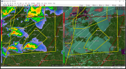
Confirmed tornado on the tornado warned storm in Mississippi. South of Philiadelphia.
CheeselandSkies
Member
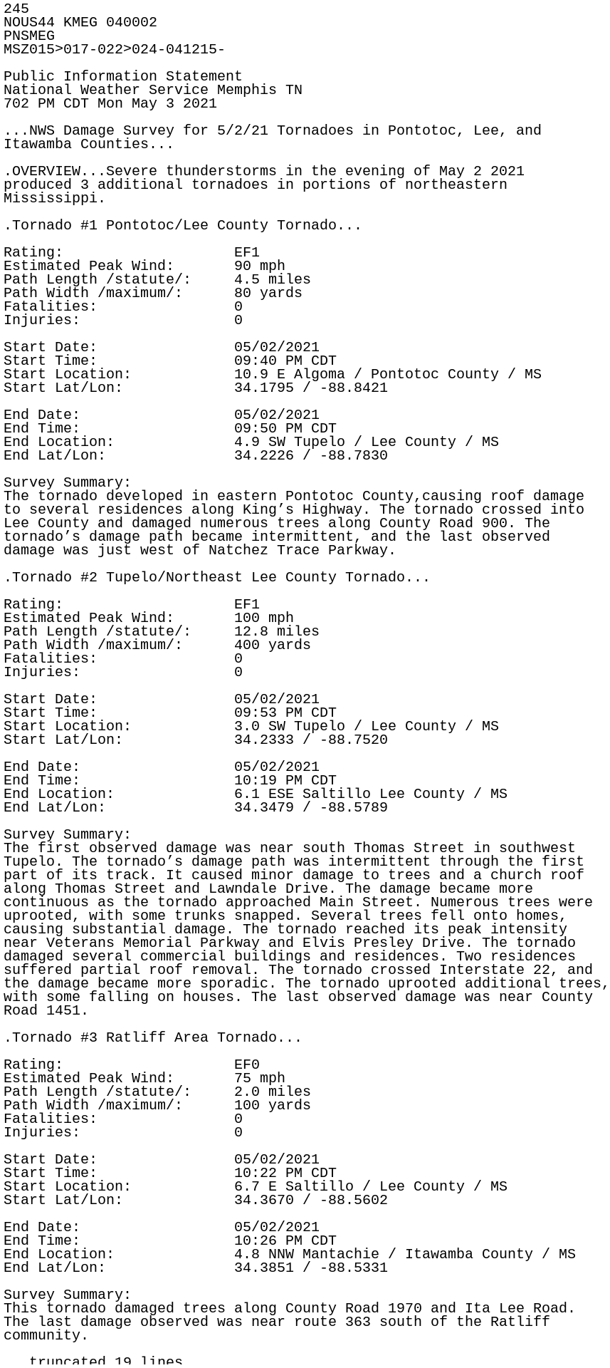
Tupelo and Yazoo City from Sunday rated EF1, although in the former case since it's MEG you wonder if they overlooked something.
Yes but that parking lot is a rather important exposure unfortunately!They do have flood barriers at all the entry points so I don’t think water gets inside like it used to. Parking lot is a different matter.
Equus
Member
Whole bunch of isolated supercells ahead of that line. Looks like flooding will become an even bigger issue.

CheeselandSkies
Member
TOR just issued on that one near Bay Springs.Whole bunch of isolated supercells ahead of that line. Looks like flooding will become an even bigger issue.
View attachment 9468
- Thread starter
- #434
Bama Ravens
Member
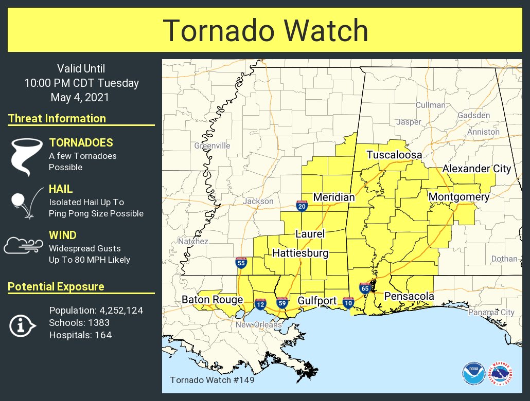
New tornado watch. The previous watch for this general area expires at 4pm.
RainyMorning
Member
I have heard from all my family in the Jackson area, all are ok. The storm passed a couple of miles from my sister in law's and my parent's houses, but other than no power they're ok. My sister was on her way home in the Brandon area and said there's a bunch of trees down everywhere.
Gail
Member
Gail
Member
Tupelo - just thought it was an awesome pic
- Thread starter
- #438
Bama Ravens
Member
Northern part of the line seems to be weakening.
Argus
Member
This event had a few similarities' to the 2003 event. We had the severe weather event in GA 05/06/03 and 5/3/21 followed by the flooding in the Birmingham area on 5/7/03 and today.
Equus
Member
Really suspicious of the back edge of the trailing rain mass; with the sharp reflectivity boundary and very high velocities shown as it trails off I wonder if we're getting into a high wind event as it passes