• Welcome to TalkWeather!
    We see you lurking around TalkWeather! Take the extra step and join us today to view attachments, see less ads and maybe even join the discussion.
    CLICK TO JOIN TALKWEATHER

Severe WX Severe Weather Threat: May 2-5, 2021

Bama Ravens

Member
Messages
1,207
Reaction score
648
Location
Morris, AL (Northern Jefferson County)
Tuesday:

day1otlk_1200.gif


Wednesday:

day2otlk_0600.gif
 
Last edited:

buckeye05

Member
Messages
3,121
Reaction score
4,581
Location
Colorado
Just an update on my chase trip, it’s been absolutely abysmal so far lol. Sitting near Jena, LA watching what are pretty much garden variety thunderstorms. Ah well.

Just happy to check out Dixie and the Plains though. Gonna try our luck in SW Missouri tomorrow, however.
 

WhirlingWx

Member
Messages
323
Reaction score
320
Location
Northern DFW Metroplex
Radar-confirmed tornado in Greene county, AL. Couplet is not much but there is a clear signature on CC from it

EDIT: This seems like one of those "power showers" or small transient supercells(?). I don't know what the correct term for it would be and someone can correct me if they know.


Equus

Member
Messages
3,290
Reaction score
3,368
Location
Jasper, AL
Special Affiliations
  1. SKYWARN® Volunteer
Absolutely didn't see that coming today

New tornado warning for Sumter
 

Equus

Member
Messages
3,290
Reaction score
3,368
Location
Jasper, AL
Special Affiliations
  1. SKYWARN® Volunteer
At least 6 is on, but yeah, wouldn't be shocked if there's no one in the studio rn to cover it at many of the stations; this is definitely unexpected
 

WhirlingWx

Member
Messages
323
Reaction score
320
Location
Northern DFW Metroplex
Uhhh I don't think this is right lol but regardless yeah the environment doesn't scream "tornado warnings" at much of any forecastable lead time.
 

Attachments

  • mesoanalysislol.jpg
    mesoanalysislol.jpg
    343.9 KB · Views: 0

TCLwx

Member
Messages
109
Reaction score
68
Location
Tuscaloosa, AL
At least 6 is on, but yeah, wouldn't be shocked if there's no one in the studio rn to cover it at many of the stations; this is definitely unexpected
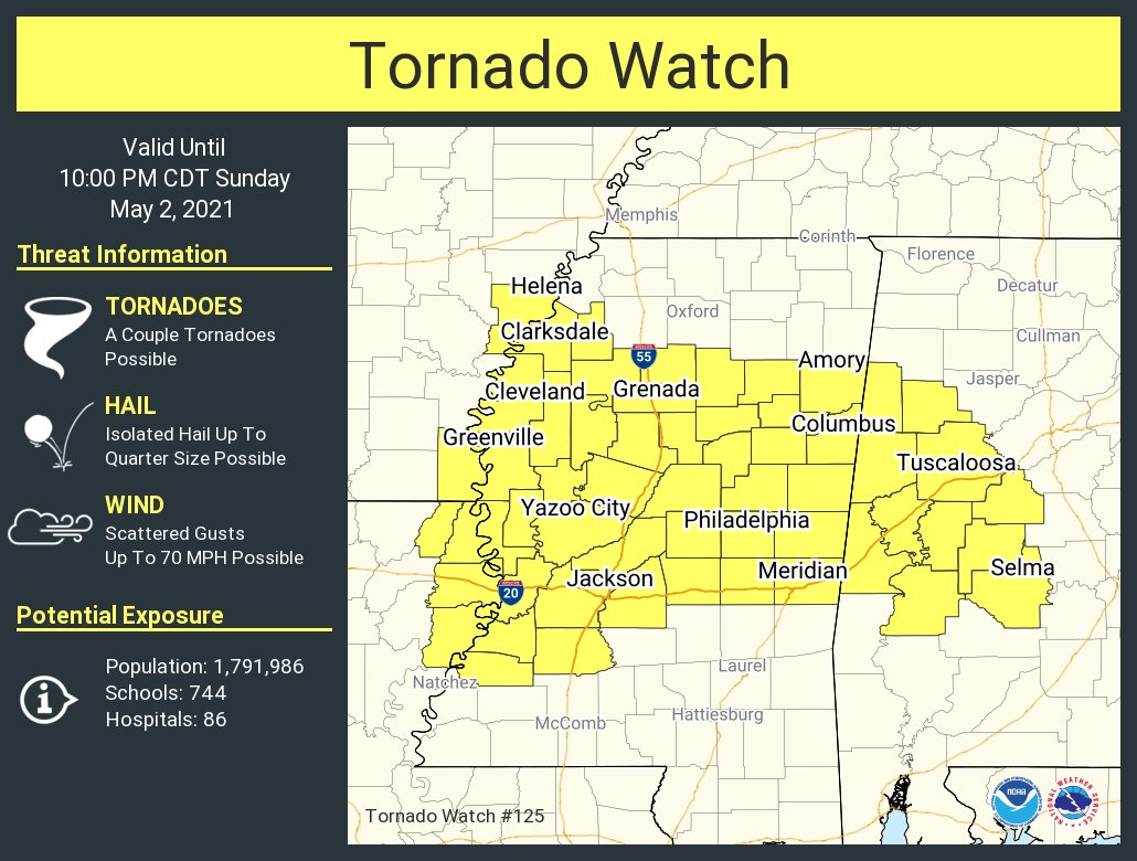
Looks like they're all on except 33/40 now. I was floored when my alert went off.
 

Equus

Member
Messages
3,290
Reaction score
3,368
Location
Jasper, AL
Special Affiliations
  1. SKYWARN® Volunteer
VWP from Columbus indicates decent speed and directional shear, can assume it's higher in the radar hole where those are

download (1).png
 

WhirlingWx

Member
Messages
323
Reaction score
320
Location
Northern DFW Metroplex
Two more tornado warnings just went up... some feisty little couplets on these cells.

EDIT: the one other than that posted above is an extension of a previous one between the Gainesville and Eutaw area .
 

WhirlingWx

Member
Messages
323
Reaction score
320
Location
Northern DFW Metroplex
1619991801358.png
Mesoscale Discussion 0477
NWS Storm Prediction Center Norman OK
0441 PM CDT Sun May 02 2021

Areas affected...western Alabama.

Concerning...Severe potential...Tornado Watch likely

Valid 022141Z - 022245Z

Probability of Watch Issuance...95 percent

SUMMARY...Small supercells with a history of producing tornadoes may
continue to pose a risk for brief tornadoes over the next couple of
hours as a warm front lifts northeastward.

DISCUSSION...21z surface analysis showed a diffuse warm front across
western Alabama and eastern Mississippi. Several small supercells
have developed over the last within the deep surface moisture to the
southwest of the warm front. Weak destabilization, MLCAPE around 500
J/kg, will likely continue to support weak convection for at least a
couple of hours. Backed low-level winds along the front are
enhancing low-level shear with 0-1km SRH of 150-200 m2/s2. Hi-res
guidance and observational trends suggest a corridor of tornado
potential will likely exists for at least a couple of hours as
storms move to the northeast along the front. Coverage is expected
to remain low, but a few tornadoes will be possible. Portions of
west-central Alabama will be included in a Tornado Watch being
coordinated across Mississippi.

..Lyons/Gleason.. 05/02/2021
 
Back
Top