Mesoscale Discussion #874
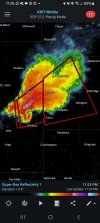
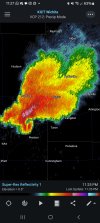
SUMMARY...An increase in strong thunderstorm development appears possible through Noon to 2 PM CDT. This may include evolving supercells, accompanied by a risk for tornadoes, in addition to large hail. Trends are being monitored for the possibility of a severe weather watch.
DISCUSSION...A few cells have begun intensifying within a broader area of convective development now spreading northeast of the I-35 corridor of central Texas. This appears to have been initially supported by large-scale forcing for ascent associated with warm advection based near the 700 mb level, downstream of a mid/upper perturbation within the belt of westerlies emanating from the lower-latitude eastern Pacific. However, the stronger convective cores have probably begun to acquire updraft inflow emanating from the seasonably moist boundary-layer.
The downstream downstream environment remains capped by an elevated mixed layer based near/above 850 mb, but is warming with insolation. Coupled with the forcing for ascent, erosion of the inhibition may allow for a substantive further increase in stronger thunderstorm development during the next several hours. This may include a few intensifying supercells. In the presence of at least modestly enlarging, clockwise curved low-level hodographs, this activity may become accompanied by a risk for tornadoes, in addition to large hail.