
Navigation
Install the app
How to install the app on iOS
Follow along with the video below to see how to install our site as a web app on your home screen.
Note: This feature may not be available in some browsers.
More options
-
Welcome to TalkWeather! We see you lurking around TalkWeather! Take the extra step and join us today to view attachments, see less ads and maybe even join the discussion. CLICK TO JOIN TALKWEATHER
You are using an out of date browser. It may not display this or other websites correctly.
You should upgrade or use an alternative browser.
You should upgrade or use an alternative browser.
Severe Weather Threat May 17-19, 2025
- Thread starter Brice W
- Start date
Ozonelayer
Member
Dang, didn't excpect that."However, the mesoscale details of the forecast result in considerable uncertainty regarding the corridors of greatest risk."
From the new D1 outlook, it looks like a high risk was considered
Kds86z
Member
US_Highway15
Member
I would've honestly been stunned if they went HIGH with this outlook, because the question to me still remains to be storm mode and how long the supercells stay discrete before they gel into a line. If there was a chance for long-track supercells then I would've supported a HIGH risk upgrade."However, the mesoscale details of the forecast result in considerable uncertainty regarding the corridors of greatest risk."
From the new D1 outlook, it looks like a high risk was considered
Kds86z
Member
I would've honestly been stunned if they went HIGH with this outlook, because the question to me still remains to be storm mode and how long the supercells stay discrete before they gel into a line. If there was a chance for long-track supercells then I would've supported a HIGH risk upgrade.
Yeah it’s not happening. Way too complicated and messy.
Muwx
Member
I don't really read that as a high risk was considered. I think its more so way we have such a big moderate risk."However, the mesoscale details of the forecast result in considerable uncertainty regarding the corridors of greatest risk."
From the new D1 outlook, it looks like a high risk was considered
Central Ohio Wx
Member
Apparently most residents sheltered in a well-built church (thank god!) but I think there's been some pretty bad damage there.Any reports of injuries or fatalities out of Plevna? From what I'm seeing there may not even be any injuries which is a miracle.
Kds86z
Member
I don't really read that as a high risk was considered. I think its more so way we have such a big moderate risk.
Yeah honestly, the same here.
lake.effect
Member
Yeah it’s not happening. Way too complicated and messy.
The main storms haven't even initiated yet...
Kds86z
Member
AJS
Member
The image won’t load.
Kds86z
Member
The main storms haven't even initiated yet...
So?.. has nothing to do with a high risk being issued lol.
AJS
Member
Send it in a DM if you’d like!The image won’t load.
Kds86z
Member
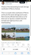
Here..Send it in a DM if you’d like!
Attachments
From Reed
TORNADO OUTBREAK IMMINENT central into eastern Oklahoma, northwestern Arkansas into western Missouri this afternoon and evening!
Supercells are already erupting across central into eastern Oklahoma and will pack a threat of all hazards including strong-to-violent tornadoes.
Stay tuned to severe weather watches and warnings in this risk area!
Kds86z
Member
The main storms haven't even initiated yet...
I meant the high risk isn’t happening, not that tornados aren’t.
AJS
Member
Awful damage. What’s crazy is that’s probably not the worst damage caused so far.Here..

Kds86z
Member
From Reed
TORNADO OUTBREAK IMMINENT central into eastern Oklahoma, northwestern Arkansas into western Missouri this afternoon and evening!
Supercells are already erupting across central into eastern Oklahoma and will pack a threat of all hazards including strong-to-violent tornadoes.
Stay tuned to severe weather watches and warnings in this risk area!
View attachment 42535
“Never change Reed”
AJS
Member
Reed is sure never hesitant to say the V word.“Never change Reed”