Aaron Rider
Member
Man, tornadoes can't get enough of Arkansas and the mid MS valley this year
Follow along with the video below to see how to install our site as a web app on your home screen.
Note: This feature may not be available in some browsers.
Man, tornadoes can't get enough of Arkansas and the mid MS valley this year
I think Sunday and Monday have the potential to be the highest ceiling days of the year so far. Think the only failure mode I can find right now is whether the cap breaks, and I think it will. Going out on a limb but I would not be surprised at all to see back to back high risks should the cams show enough convective coverage.What is the current potential ceiling for this event based on what we know?


Heck yeah!Ummm.....
View attachment 42052
Ummm.....
View attachment 42052

Ugh not again..View attachment 42054
Antenna raised.
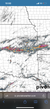
SPC brief below for D4 below.
Day 4-8 Convective Outlook
NWS Storm Prediction Center Norman OK
0340 AM CDT Sat May 17 2025
Valid 201200Z - 251200Z
...DISCUSSION......Day 4/Tuesday...
As the primary mid-level trough shifts east on Tuesday, scattered severe thunderstorms are likely across parts of the Mid-Mississippi Valley into the Tennessee Valley. Upper 60s to low 70s dewpoints will be present ahead of a cold front. Convection/cloud cover from Day 3 convection across the Plains/Ozarks will impact destabilization across Kentucky and into the Ohio Valley. However,
farther south, strong destabilization is likely as the boundary layer heats beneath steepening mid-level lapse rates. 50 to 60 knots of mid-level flow will overspread this unstable warm sector during the afternoon Tuesday. As this occurs, an uncapped boundary layer and synoptic scale ascent should combine for scattered severe storm development. Wherever moderate to strong instability develops, most likely south of the TN/KY border, supercells are anticipated with a primary threat for large hail. By later in the evening, storms may congeal into a MCS with an increasing damaging wind threat.
Yeah and looking over stuff I see thus far has better potential than yesterdays unfortunately, the lower level shear is nearly max over parts Mid south even DixieUgh not again..
Well hello 30%.Ummm.....
View attachment 42052
Currently the main threat for DFW is large hail and high-winds.5% TOR risk for DFW, but no black marker for that today unlike last time.
And unlike last time, I've woken up to sunlight instead of the Forrest Gump downpouts?
I'll keep my eyes out
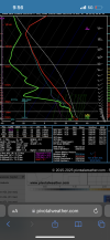
I wasn’t really looking ahead to the next couple of days until now.A bit eyebrow-raising when a box sounding averages a "PDS TOR" and over 150 j/kg 3CAPE. Southern Kansas off the 0Z NAM.
View attachment 42042