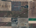
Welcome to TalkWeather!
We see you lurking around TalkWeather! Take the extra step and join us today to view attachments, see less ads and maybe even join the discussion.
CLICK TO JOIN TALKWEATHER
Moving ever closer to the edge of the instability axis. Probably going to be done before too long; in an increasingly stable environment, even the insane helicity values won't be enough to keep it going once it begins to lose inflow. Wouldn't count it out for now, but losing the best environment, the meso is messy right now
Here is the wind profile from Wichita, KS radar... Large, looping hodograph with impressive low level curvature. Crazy shear numbers: 350+ m2/s2 in the lowest 500m, 500+ below 1km, 640+ below 3km. Luckily (if you can say that) only one storm took advantage of this environment.
Yeah screw this I'm going to bed. Don't wanna think about this too much and it's already super late. Praying nobody was killed, which seems increasingly likely.
Yea, thankfully based on some footage and what I’m hearing, the tornado indeed missed the town, at least the core did.
Most houses actually turned out ok, unless the radar pulled the biggest prank ever with how high and intense the debris ball was, the brunt of the tornado definitely missed. Thank goodness.
Supercell is definitely running out of gas, and the significant tornado threat is likely coming to an end tonight. Hoping tomorrow doesn’t unveil horrible devastation, especially to the numerous farms impacted tonight. Unfortunately severe weather wise much of the same is expected tomorrow evening.
This site uses cookies to help personalise content, tailor your experience and to keep you logged in if you register.
By continuing to use this site, you are consenting to our use of cookies.