joshoctober16
Member
unwarned tornado has been going on for a storm with zero warning , hitting multiple homes 
Follow along with the video below to see how to install our site as a web app on your home screen.
Note: This feature may not be available in some browsers.
we got popped with a pretty good line of severe thunderstorms between DC and Baltimore. fortunately it hit College Park about 5 minutes after I walked off the 18th green. had to dodge at least one downed tree on the Baltimore-Washington Parkway coming home.Welp. Can't say that I saw that coming. Especially for the NE.
Radar a few minutes ago was showing 4 simultaneous tornado warnings from Ft. Smith to Mena, how is there no tornado watch?
We shall see. It’s June so stay tuned, never know and keep up to date with SPC day 1 outlooksmight go chasing tomorrow, hope the tornado risk increases (dont take this the wrong way). any of you guys think the severe threat gets uograded?
Yeah it’s out around 1am cstis day 1 already out? i thought they updated at 1am CST. 9 minutes for me
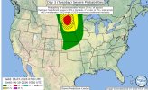
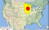
There is now a Slight Risk for Monday around where Colorado, Wyoming and Nebraska meet.Yeah this may be a bit premature bud lol
The SPC does not have an outlook for D3 (Monday) yet. We have to be careful not to title threads for extended periods of time.