• Welcome to TalkWeather!
    We see you lurking around TalkWeather! Take the extra step and join us today to view attachments, see less ads and maybe even join the discussion.
    CLICK TO JOIN TALKWEATHER

Severe WX Severe Weather Threat June 6-14

Latest:
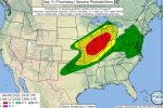
SPC isn't messing around with this one. A Day 3 30% hatched area for significant severe weather stretching from the Mid-Mississippi Valley into the Great Lakes definitely catches the eye. Still plenty of details to work out, but this is the kind of outlook that makes you start paying closer attention to future model runs and forecast updates.
 

Attachments

  • IMG_9477.jpeg
    IMG_9477.jpeg
    174.9 KB · Views: 6
Last edited by a moderator:
Now we might have to extend this thread to the 13th as the SPC has a Day 5 severe outlook for Saturday in parts of Nebraska and Kansas.
I will go ahead and edit it. I think we should take it out to the 14th just to be safe. Anything after that lets start a new thread for it.
 
Latest day 3:


..EASTERN DAKOTAS/WESTERN MINNESOTA


LATEST GOES IMAGERY AND SURFACE OBSERVATIONS SHOW A BAND OF
DEEPENING CUMULUS WITHIN A PLUME OF RICH LOW-LEVEL MOISTURE
(DEWPOINTS IN THE UPPER 60S TO LOW 70S) THROUGH THE UPPER RED RIVER
VALLEY OF THE NORTH. ADDITIONALLY, A SUBTLE MCV - THE REMNANTS OF
PRIOR CONVECTION OVER NE - IS CURRENTLY OVERSPREADING THE REGION AND
MAY PROVIDE ADEQUATE FORCING FOR ASCENT FOR INITIATION WITHIN THE
WEAKLY CAPPED AND HIGHLY BUOYANT AIR MASS THIS AFTERNOON. WHILE
CONDITIONAL, DISCRETE CONVECTION THAT CAN DEVELOP WITHIN THIS ZONE
COULD POSE A TORNADO THREAT AS LOW-LEVEL WINDS STRENGTHEN THROUGH
THE DAY. THE 10% TORNADO CONTOUR WAS EXPANDED EASTWARD INTO WESTERN
MN TO BETTER ADDRESS THIS POTENTIAL.
 
Back
Top