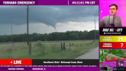
Second tornado trying to come down just south

Follow along with the video below to see how to install our site as a web app on your home screen.
Note: This feature may not be available in some browsers.


Who wants to bet the storms forming south of the Toluca tornado will turn this into an MCS and kill off the strong tornado potential.


Where is the OFB currently on the map? Is it still lifting north or stalled?When a cell that has already had a significant merger in its FFD prior to tornadogenesis, latches onto the modified OFB, that is what happens. Mesoscale dynamics at play on a day that didn't need it, but that was a high end, violent tornado, no doubt.
Any prefrontal that can sustain itself, perhaps latch onto the boundary or utilise favorable mergers, will pose a major tornado threat.
Peak intensity: 150-170 mph


I'm not trying to spark riot in a moment where it's not needed but there is seriously no need to be saying stuff like this.catastrophic scenario unfolding in central IL at the moment. multiple violent wedges from cprox cells very probable.