
If the storm on the IA/MO/IL border doesn't produce a major tornado at some point i'll eat a shoe.
Navigation
Install the app
How to install the app on iOS
Follow along with the video below to see how to install our site as a web app on your home screen.
Note: This feature may not be available in some browsers.
More options
-
Welcome to TalkWeather! We see you lurking around TalkWeather! Take the extra step and join us today to view attachments, see less ads and maybe even join the discussion. CLICK TO JOIN TALKWEATHER
You are using an out of date browser. It may not display this or other websites correctly.
You should upgrade or use an alternative browser.
You should upgrade or use an alternative browser.
Severe WX Severe Weather Threat June 6-14
- Thread starter Kds86z
- Start date
- Thread starter
- #342
Kds86z
Member
- Thread starter
- #343
Kds86z
Member
SUMMARY...THE TORNADO POTENTIAL APPEARS TO BE INCREASING ACROSS
WESTERN ILLINOIS.
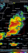
DISCUSSION...RADAR IMAGERY OUT OF KILX DEPICTS A STRENGTHENING
SUPERCELL WITH AN ORGANIZING MID-LEVEL MESOCYCLONE NEAR CARTHAGE,
IL. LIVE WEB STREAMS DEPICT A STRENGTHENING LOW-LEVEL MESOCYLONE AS
WELL, SUGGESTING THE POTENTIAL FOR TORNADOGENESIS IS INCREASING.
THIS CELL IS DRIFTING NORTHEASTWARD WITHIN A WARM ADVECTION REGIME
WHERE LOW-LEVEL SRH HAS BEEN INCREASING PER THE KILX VWP (0-1 KM SRH
HAS RECENTLY INCREASED TO 200 M2/S2). PER LATEST RAP MESOANALYSIS
ESTIMATES, DOWNSTREAM STP VALUES ARE ALSO INCREASING TO 6-7. THE
POTENTIAL FOR DESTRUCTIVE STORM INTERACTIONS APPEARS LIMITED FOR THE
SHORT TERM (NEXT HOUR OR SO), SUGGESTING THAT THE POTENTIAL FOR A
LONG-TRACK SUPERCELL IS INCREASING WITH AN ATTENDANT THREAT OR ONE
OR MORE TORNADOES, INCLUDING POSSIBLE A STRONG/INTENSE TORNADO.
..MOORE.. 06/11/2026
Beachwalker
Member
Shear vector troubles (again)? #2026weirdyear
Beachwalker
Member
Those two IL storms have moved in a more easterly motion. Could do something soon
DanLarsen34
Member
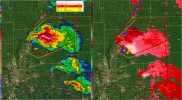
We’ve got these two cells competing right now where the top one is currently showing intense rotation. However, I wonder if we get a constructive merger of the two cells in the next 30 minutes where the southern circulation takes over.
Not saying this will happen, but the presentation reminds me of the Tuscaloosa cells before they merged and produced the Tuscaloosa/Birmingham tornado.
Not saying this will happen, but the presentation reminds me of the Tuscaloosa cells before they merged and produced the Tuscaloosa/Birmingham tornado.
Attachments
DanLarsen34
Member
The storm to the north of Peoria is looking like it may undergo a constructive merger shortly. 
Tanner
Member
I feel for some of the chasers this year. It has been a god-awful season for severe weather predictability.
This was just a figure of speech btw.If the storm on the IA/MO/IL border doesn't produce a major tornado at some point i'll eat a shoe.
DanLarsen34
Member
as is the standard in 2026, these cells got blobby AF now and look like they’re congealing into an MCS. I swear, every time pattern recognition would suggest the potential of a storm is increasing this year, the opposite happens.We’ve got these two cells competing right now where the top one is currently showing intense rotation. However, I wonder if we get a constructive merger of the two cells in the next 30 minutes where the southern circulation takes over.
Not saying this will happen, but the presentation reminds me of the Tuscaloosa cells before they merged and produced the Tuscaloosa/Birmingham tornado.
Beachwalker
Member
Those two IL storms have moved in a more easterly motion. Could do something soon
Aaaaand it’s gone
Potentially violent tornado near Metamora IL!
Tanner
Member
I literally was about to say bust what the hell.Potentially violent tornado near Metamora IL!
- Thread starter
- #355
Kds86z
Member
Seasons of weather
Member
That went up so fast, wow (referring to Peoria cell). Tracking right into Chicago area in an hour or two
jiharris0220
Member
Already a debris ball, when you get these extremely high shear set ups it really doesn’t take long at all.
Just one supercell that manages to root and stay discrete long enough is all it took.
Just one supercell that manages to root and stay discrete long enough is all it took.
- Thread starter
- #358
Kds86z
Member

HUGE debris ball! absolutely blasted up to 20k feet