- Thread starter
- #61
Kds86z
Member
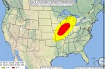
Just had a brief but potentially damaging tornado near Sparta, MO. Warning went to TORR status one minute after its initial issuance.
View attachment 53164View attachment 53165
Follow along with the video below to see how to install our site as a web app on your home screen.
Note: This feature may not be available in some browsers.
Just had a brief but potentially damaging tornado near Sparta, MO. Warning went to TORR status one minute after its initial issuance.
View attachment 53164View attachment 53165


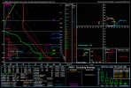
8900 CAPE?! Holy $hit! It's worth noting a wet bulb temp of 88 is considered deadly for healthy adults. 86 is deadly for young children and the elderly. This sounding is showing around 83 or 84.With vertical instability of this caliber underneath an inversion layer like this, you can legitimately go from a small puff of cumulus humulus to a full mature supercell over a 100miles long in the span of 30minutes.
Obviously this is the 3km NAM here and over 2days out. Nebraska really has a low chance of seeing convection even with this environment because the forcing mechanism will be too far north.
View attachment 53157


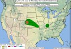
Don't think I'm so convinced given recent runs. Surface analysis would suggest the same too. Peak intensity today downgraded to 80-100 mph.Today could get interesting in Colorado. My peak intensity guidance is reaching 120-140 mph. These profiles have produced significant tornadoes + extremely large hail combo before.
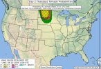
Day 4:
A VERY MOIST AIR MASS IS EXPECTED TO RESIDE TO THE SOUTH OF THE
SURFACE FRONT, WHICH COUPLED WITH MODESTLY STEEP MID-LEVEL LAPSE
RATES IS EXPECTED TO YIELD MODERATE TO STRONG INSTABILITY. THE
PRESENCE OF A 50-70 KT MID-LEVEL JET STREAK ATTENDING THE SHORT-WAVE
TROUGH WILL RESULT IN RELATIVELY STRONG DEEP-LAYER SHEAR ALONG THE
FRONTAL ZONE, WITH VECTOR ORIENTATION BECOMING INCREASINGLY PARALLEL
TO THE BOUNDARY WITH SOUTHWARD EXTENT. THE OVERALL PATTERN APPEARS
SUPPORTIVE OF AN ORGANIZED SEVERE-WEATHER EPISODE FROM THE UPPER
GREAT LAKES INTO MID MS VALLEY. THERE IS SOME MODEL SIGNAL THAT A
CORRIDOR OF ENHANCED TORNADO POTENTIAL COULD DEVELOP ALONG AND SOUTH
OF THE SURFACE LOW TRACK FROM EASTERN IA AND NORTHERN IL INTO
CENTRAL AND SOUTHERN WI. THAT POTENTIAL SCENARIO WILL BE DICTATED BY
THE LOCATION OF THE EFFECTIVE SURFACE BOUNDARY.