
Navigation
Install the app
How to install the app on iOS
Follow along with the video below to see how to install our site as a web app on your home screen.
Note: This feature may not be available in some browsers.
More options
-
Welcome to TalkWeather! We see you lurking around TalkWeather! Take the extra step and join us today to view attachments, see less ads and maybe even join the discussion. CLICK TO JOIN TALKWEATHER
You are using an out of date browser. It may not display this or other websites correctly.
You should upgrade or use an alternative browser.
You should upgrade or use an alternative browser.
Severe Weather Threat June 5-9
- Thread starter Kds86z
- Start date

TornadoFan
Member
New Mexico storm.

- Thread starter
- #423
Kds86z
Member
 even in June
- Thread starter
- #424
Kds86z
Member
N
Not here anymore
Guest
BULLETIN - EAS ACTIVATION REQUESTED
TORNADO WARNING
NATIONAL WEATHER SERVICE MEMPHIS TN
755 PM CDT SAT JUN 7 2025
THE NATIONAL WEATHER SERVICE IN MEMPHIS HAS ISSUED A
* TORNADO WARNING FOR...
SOUTHEASTERN LEE COUNTY IN EASTERN ARKANSAS...
NORTHEASTERN PHILLIPS COUNTY IN EASTERN ARKANSAS...
NORTHEASTERN COAHOMA COUNTY IN NORTHWESTERN MISSISSIPPI...
TUNICA COUNTY IN NORTHWESTERN MISSISSIPPI...
NORTH CENTRAL QUITMAN COUNTY IN NORTHWESTERN MISSISSIPPI...
* UNTIL 845 PM CDT.
Interesting Fact: The last Tornado Warning issued on June 7th in North MS was back in 2014.
Two tornado warnings in northwest MS

- Thread starter
- #429
Kds86z
Member
- Thread starter
- #430
Kds86z
Member
What a wild several days. Glad I made a thread. I appreciate y’all joining in.
brianc33710
Member
The SPC has Bham in Marginal 1/5 but BMX has us in Slight/2. Why the descripency?

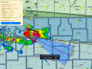
That's a strong. Couplet south of Memphis

We may have a tornado down soon east of senatobia
jiharris0220
Member
Tornado might occur in the next scan or two.

Yes, but SPC would have to have high end confidence in doing so.Is it possible tomorrow 6/8 gets upgraded to a high-risk. Guessing it would be a wind driven high-risk.
Ledian
Member
Sirens sounded here for a little bit. I understand why, but the polygon ended 11 miles west of town. Feels a bit weird to me
brianc33710
Member
@Jbop Supposedly that's only happened 2× & both over a decade ago. So I have my doubts. You'll have an overall MDT Risk with a High/45-59% hatched Wind & possibly a MDT-HIGH or 30-44/45-59% hatched Hail area. EDIT Tornado risk is only 5%. Tornadoes are usually the only things "sexy" enough to attract the already very rare High Risk days.@Ledian maybe your county has a "legacy" system where sirens sound for everyone when a tornado warning affects anyone in the county.Yes, but SPC would have to have high end confidence in doing so.
Last edited: