
- Thread starter
- #361
Navigation
Install the app
How to install the app on iOS
Follow along with the video below to see how to install our site as a web app on your home screen.
Note: This feature may not be available in some browsers.
More options
-
Welcome to TalkWeather! We see you lurking around TalkWeather! Take the extra step and join us today to view attachments, see less ads and maybe even join the discussion. CLICK TO JOIN TALKWEATHER
You are using an out of date browser. It may not display this or other websites correctly.
You should upgrade or use an alternative browser.
You should upgrade or use an alternative browser.
Severe Weather Threat June 5-9
- Thread starter Kds86z
- Start date
- Thread starter
- #362
Kds86z
Member
CheeselandSkies
Member
Although I didn't get up in time to save screenshots from GR Level 3, it looks like there was a radar-confirmed tornado in northeastern Oklahoma around 0520 CDT this morning.
This snippet from the Day 2 outlook also caught my eye:
" ...Southern Great Plains...
The active severe-weather pattern across the region may peak during
late afternoon to evening Sunday."
This suggests to me they think tomorrow has a higher ceiling than either yesterday or Thursday.
This snippet from the Day 2 outlook also caught my eye:
" ...Southern Great Plains...
The active severe-weather pattern across the region may peak during
late afternoon to evening Sunday."
This suggests to me they think tomorrow has a higher ceiling than either yesterday or Thursday.
Last edited:
Kinda surprised at no moderate, looks to be a decent chance for a derecho or atleast a very robust large bow echo
Big time wind bagKinda surprised at no moderate, looks to be a decent chance for a derecho or atleast a very robust large bow echo

Eoline
Member
Kinda dumb question, but is there a “derecho alley” in the United States? Most times they’ve happened, it seems to be over the general Midwest and sometimes the southeast. Surprised it hasn’t been definitively named, yet.
Kolle
Member
Kinda dumb question, but is there a “derecho alley” in the United States? Most times they’ve happened, it seems to be over the general Midwest and sometimes the southeast. Surprised it hasn’t been definitively named, yet.

This is from the NWS in Louisville.
- Admin
- #368
- Messages
- 2,433
- Reaction score
- 2,273
- Location
- Meridianville, Al
- Special Affiliations
- SKYWARN® Volunteer
The way derecho is actually pronounced and the way I always want to pronounce it is always at odds in my head.
The way it sounds: duh-ray-shee-yoh!The way derecho is actually pronounced and the way I always want to pronounce it is always at odds in my head.
The way my brain wants to say it: Durr-echo
- Admin
- #370
- Messages
- 2,433
- Reaction score
- 2,273
- Location
- Meridianville, Al
- Special Affiliations
- SKYWARN® Volunteer
For me, the emphasis is on the first syllable. DER-uh-koThe way it sounds: duh-ray-shee-yoh!
The way my brain wants to say it: Durr-echo
CheeselandSkies
Member
The way derecho is actually pronounced and the way I always want to pronounce it is always at odds in my head.
The way it sounds: duh-ray-shee-yoh!
The way my brain wants to say it: Durr-echo
For me, the emphasis is on the first syllable. DER-uh-ko
For a long time (when I'd never heard it spoken, only read it) I pronounced it DAY-ray-cho.
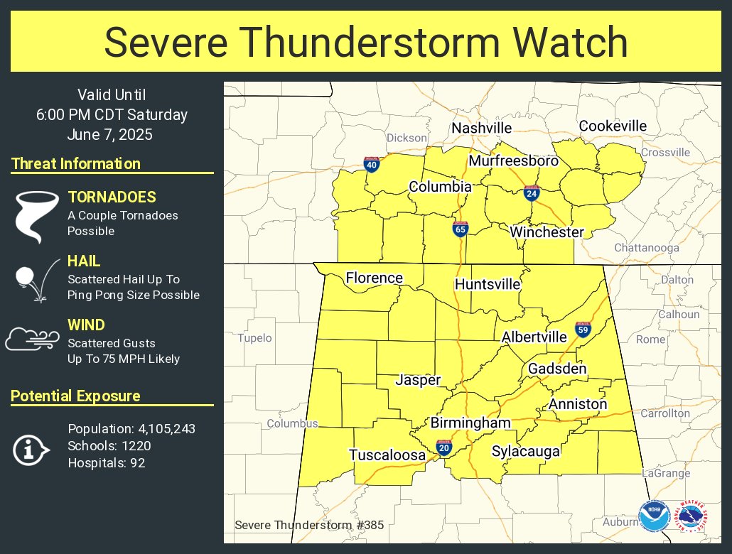
Watch forthcoming for Alabama and middle Tennessee.
Storm Prediction Center Mesoscale Discussion 1175
Severe weather, tornado, thunderstorm, fire weather, storm report, tornado watch, severe thunderstorm watch, mesoscale discussion, convective outlook products from the Storm Prediction Center.
www.spc.noaa.gov
tempostorm
Member
Ive just been casually checking the radar seems like the line isnt as bad as earlier is it supposed to restrengthen later into al/ga?
Im speed running cutting my grass and my grannies grass so I can beat this MCS lol. It's definitely humid out here for severe thunderstormsWatch forthcoming for Alabama and middle Tennessee.
Storm Prediction Center Mesoscale Discussion 1175
Severe weather, tornado, thunderstorm, fire weather, storm report, tornado watch, severe thunderstorm watch, mesoscale discussion, convective outlook products from the Storm Prediction Center.www.spc.noaa.gov
Bama Ravens
Member
Stuff like that is a good part of why the hobby is called "storm chasing" instead of "storm catching".Was watching Jordan Hall's stream on Severe Studios. He hauled butt to get around Lubbock into the gnarly road network that the eastern storm is heading into, then decided to abandon it at Post and head west on 380 for the one that is currently tornado-warned, then after about 10 miles changed his mind and turned around again thinking the eastern one is looking too good, even though it's only severe-warned and is heading into an even worse road hole.
*Now I turned the stream back on and it looks like he's headed west again. Vacillating like that is how you b*st.
I almost did that myself on 281 south of Pratt on May 18th, turning around once and starting to head back to town, targeting the area that eventually produced the Nettleton/Garfield EF2, before turning around again and committing to Oklahoma.

Ledian
Member
Man, that didn't last long, but it sure was nasty. Power flickered before it even arrived, but it's stayed on the whole time.
Near Saltillo might've had an unwarned tornado earlier
Near Saltillo might've had an unwarned tornado earlier
Ledian
Member
JPWX, i hope things don't/didn't get too bad where you're at. 80 MPH wind gusts...yikes.
That's a fairly sizeable PDS severe thunderstorm warning
Equus
Member
Well this doesn't look fun