WeathermanLeprechaun
Member
StormNet has turned itself into a remarkable tool and i think I caught the most insane instance of it verifying today.
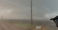
It's not hard to verify a major outbreak by its standard but today, it outlined south of Gillette, WY specifically for a 10%+ chance of tornadoes. I checked soundings and went "meh not much shear but what is it onto". Fast forward to around two hours ago, a supercell tracked south of Gillette and dropped multiple brief tornadoes.
It's undeniable that this is easily the most promising tool for tornado forecasting seen in a very long while. No idea how it managed to pinpoint THAT exact area but this is showing you the capabilities of this tool already. Incredible.