- Thread starter
- #361
Navigation
Install the app
How to install the app on iOS
Follow along with the video below to see how to install our site as a web app on your home screen.
Note: This feature may not be available in some browsers.
More options
-
Welcome to TalkWeather! We see you lurking around TalkWeather! Take the extra step and join us today to view attachments, see less ads and maybe even join the discussion. CLICK TO JOIN TALKWEATHER
You are using an out of date browser. It may not display this or other websites correctly.
You should upgrade or use an alternative browser.
You should upgrade or use an alternative browser.
Severe WX Severe Weather Threat June 19-23
- Thread starter Kds86z
- Start date
- Thread starter
- #362
Kds86z
Member
Brad is live in Huntsville

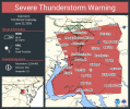
Likely a TOG with this now-TOR-warned storm northeast of Huntsville.Suspicious formation near New Market, Alabama. This storm merged with the line and has a pretty notable couplet.
View attachment 53861


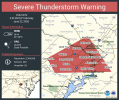
Now radar-confirmed TORR.Wow, very strong couplet and a growing TDS visible east of New Market.
View attachment 53863
Severe Weather Statement
National Weather Service Huntsville AL
407 PM CDT Mon Jun 22 2026
ALC071-089-TNC051-222130-
/O.CON.KHUN.TO.W.0005.000000T0000Z-260622T2130Z/
Jackson AL-Madison AL-Franklin TN-
407 PM CDT Mon Jun 22 2026
...A TORNADO WARNING REMAINS IN EFFECT UNTIL 430 PM CDT FOR
NORTHWESTERN JACKSON...NORTHEASTERN MADISON AND SOUTH CENTRAL
FRANKLIN COUNTIES...
At 407 PM CDT, a confirmed tornado was located near New Market, or 10
miles northeast of Moores Mill, moving east at 45 mph.
HAZARD...Damaging tornado.
SOURCE...Radar confirmed tornado.
IMPACT...Flying debris will be dangerous to those caught without
shelter. Mobile homes will be damaged or destroyed. Damage
to roofs, windows, and vehicles will occur. Tree damage is
likely.
Locations impacted include...
Skyline, New Market, Hytop, Estillfork, Francisco, and Larkin.
PRECAUTIONARY/PREPAREDNESS ACTIONS...
To repeat, a tornado is on the ground. TAKE COVER NOW! Move to a
basement or an interior room on the lowest floor of a sturdy
building. Avoid windows. If you are outdoors, in a mobile home, or in
a vehicle, move to the closest substantial shelter and protect
yourself from flying debris.
&&
LAT...LON 3482 8606 3487 8643 3495 8643 3506 8614
TIME...MOT...LOC 2107Z 248DEG 38KT 3494 8636
TORNADO...OBSERVED
MAX HAIL SIZE...<.75 IN
warneagle
Member
- Moderator
- #369
Is more supposed to pop up later or is that it? Lights blinked but this time they actually stayed on.
RFD66
Member
Debris aloft just East of New Market

joshoctober16
Member
a lot of tornado reports on the west side of the usa right now 
joshoctober16
Member
landspouts and hybrid fest happening here right now at these 4 storms

- Thread starter
- #374
Kds86z
Member
- Thread starter
- #375
Kds86z
Member
Stay on guard, there's still activity expected to come in from the west.Is more supposed to pop up later or is that it? Lights blinked but this time they actually stayed on.