
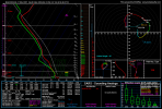
The 3km NAM is having difficulties.
Navigation
Install the app
How to install the app on iOS
Follow along with the video below to see how to install our site as a web app on your home screen.
Note: This feature may not be available in some browsers.
More options
-
Welcome to TalkWeather! We see you lurking around TalkWeather! Take the extra step and join us today to view attachments, see less ads and maybe even join the discussion. CLICK TO JOIN TALKWEATHER
You are using an out of date browser. It may not display this or other websites correctly.
You should upgrade or use an alternative browser.
You should upgrade or use an alternative browser.
Severe Weather Threat - June 17th-18th, 2023
- Thread starter Taylor Campbell
- Start date
- Thread starter
- Moderator
- #22
The EURO presents a strong low level jet. The GFS has been much less impressive, but appears to be an outlier.
- Thread starter
- Moderator
- #23
Heads up on the tornado threat tomorrow across southern AL, Mobile Bay area into the FL panhandle as guidance has picked up steam on the risk.
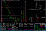
The 2 soundings I looked at from the 12km NAM in Arkansas (Central/Northeast) are absolutely ridiculous. One might be a bad sounding, but nonetheless, both are insane.
Attachments
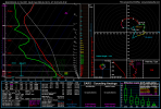
General dynamics in that area the last several runs have been assuredly bonkers. Reeeeaaally hoping they don't come close to verifying.The 2 soundings I looked at from the 12km NAM in Arkansas (Central/Northeast) are absolutely ridiculous. One might be a bad sounding, but nonetheless, both are insane.
Hailing here at my house marble size northeast of Birmingham. Anybody know someone at the nws of bham? There's no severe warning.
Our power just came back on a few minutes ago. Got a lot of heavy rainfall and thunder/lightning.
Ping pong size hail in northeast of remlap my friend says.
They finally warned it.
They finally warned it.
Gail
Member
Driving from Tuscaloosa to Columbus - around Gordo. My town of Caledonia had golfball-softball+ sized hail. Hoping we don’t have damage when we get home.


Golf ball size hail from my friend about 5 minutes away from meDriving from Tuscaloosa to Columbus - around Gordo. My town of Caledonia had golfball-softball+ sized hail. Hoping we don’t have damage when we get home.
View attachment 20654
View attachment 20655
View attachment 20656
View attachment 20657
Attachments

Tomcats Forever!
Member
Go home NAM, you're drunk. (Or on meth)The 2 soundings I looked at from the 12km NAM in Arkansas (Central/Northeast) are absolutely ridiculous. One might be a bad sounding, but nonetheless, both are insane.
That greenish color is usually indicative of a hail core I believe. That's crazy! All this is crazy.Driving from Tuscaloosa to Columbus - around Gordo. My town of Caledonia had golfball-softball+ sized hail. Hoping we don’t have damage when we get home.
View attachment 20654
View attachment 20655
View attachment 20656
View attachment 20657
I've always associated that with tornadic storms. Looking at radar velocities its been spinning pretty good up high in the atmosphere.That greenish color is usually indicative of a hail core I believe. That's crazy! All this is crazy.
Currently that same storm has a absolutely massive hail core on radar.
Gail
Member
It was showing 4” hail on RadarScope. We got a few pellets but skirted north of the worst of it. We did see some chasers out. I've always associated that with tornadic storms. Looking at radar velocities its been spinning pretty good up high in the atmosphere.
Currently that same storm has an absolutely massive hail core on radar.

Gail
Member
Gail
Member
Even larger ones pictured in the comments.
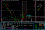
00z NAM sounding for Northwest MS, Itawamba County, MS, and Monroe County, MS late Sunday going into Monday.
Attachments
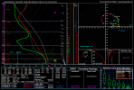
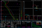
NAM is definitely refusing to let up here. Definitely not a fan of the reflectivity presentation on it for Sunday or Monday.00z NAM sounding for Northwest MS, Itawamba County, MS, and Monroe County, MS late Sunday going into Monday.


If the NAM is correct, then I would expect to see SPC ramp up the tornado threat outside of the damaging wind/large hail potential. Wouldn't be surprised to see a Enhanced Risk by tomorrow with the potential for a further upgrade to Moderate (mainly for damaging wind if so)