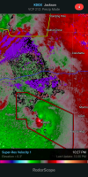
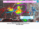
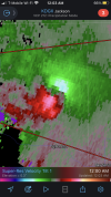
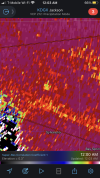
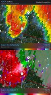
Severe Weather Threat - June 17th-18th, 2023

It just feels like these storms are stuck in slow motion.
 
Flash flood threat increasing overnight with potential for locally 4 to 6+
 

Attachments

  • mcd0520.gif
    mcd0520.gif
    77.9 KB · Views: 0
The circulation is much stronger northeast of Raleigh, and it looks like a wrap around on the backside north of town.
 
TOG near Sylvarena, MS
 

Attachments

  • C901A7D3-2A0A-4714-9D15-A3ACE01039B8.png
    C901A7D3-2A0A-4714-9D15-A3ACE01039B8.png
    417.3 KB · Views: 0
  • 12E1107D-FDB6-41D8-8710-23974EE22871.png
    12E1107D-FDB6-41D8-8710-23974EE22871.png
    365.3 KB · Views: 0
Last edited by a moderator:
I'm wondering if that warm front will keep pressing north bound. WPC seems to think so.
 
Back
Top