Kds86z
Member
Remember- this is the anniversary of 4 EF4s in NE, Pilger twins 2014 and also Minnesota F5 1992. This date shall be remembered.
Follow along with the video below to see how to install our site as a web app on your home screen.
Note: This feature may not be available in some browsers.
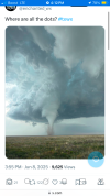
when the parameters match up with everything in typical hybrid tornado on a boundary
or
landspout that forms or moves under a mesocyclone.
it seem to be very landspout ish at the very start of its life.
in other words this image might help
View attachment 44136
hard to tell with the velocity but it almost looks like the landspout formed first and the mesocyclone formed above it after.
Last Sunday.wait what Oklahoma tornado was Andrew talking about?
...? wait there was a tornado in Oklahoma on June 15?Last Sunday.
Remember?? You even posted on it...? wait there was a tornado in Oklahoma on June 15?
just to be sure can some one post a video of what tornado Andrew is talking about.
 and said was hybrid
Last Sunday ... not yesterday...? wait there was a tornado in Oklahoma on June 15?
just to be sure can some one post a video of what tornado Andrew is talking about.
oh... last sunday means .. june 15 ....Last Sunday ... not yesterday