CheeselandSkies
Member
All right, thread time. By now the models seem to be keying in on Friday as the main day of interest, although depending on the model/run, Thursday may hold some marginal potential somewhere.


Follow along with the video below to see how to install our site as a web app on your home screen.
Note: This feature may not be available in some browsers.

I'm sure this isn't the best way to move a post but I'm a dum dum.Well hello, hello! CIPS seems to have pretty high confidence in a potentially significant severe risk late next week. Can't say I disagree. IF GFS holds its current presentation on the latest run, you're looking at a pretty classic, substantial cold season severe setup. Low placement is "perfect" as one can get for the South. Moisture return modelled is a little squished but I'm not sure I totally buy that with the strength of the system itself. Again, if it continues to uptrend like it has, feels like we could definitely see something pretty significant out of this.
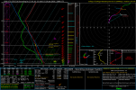
View attachment 49555View attachment 49556
View attachment 49557View attachment 49558
Somewhat depends on locale. Your sounding, from Missouri, much closer to the actual front, is a lot less curved. Further out, across the Southeast, there's plenty of curvature (this sounding from northern AL/MS line; I know there's no instability, just showing hodos here).Shear vectors I still think support more of a linear mode, but yeah, 12z GFS goes back to previous trends with the potential for a tornado threat and a bit of instability to get it done.

These situations with very strong speed shear can produce tornadoes too, but it would be preferred to have a hodograph like yours at hand. It all depends on line orientation to really make this type of strong SRI combo properly work. It can be very efficient at tornadogenesis in the right setupSomewhat depends on locale. Your sounding, from Missouri, much closer to the actual front, is a lot less curved. Further out, across the Southeast, there's plenty of curvature (this sounding from northern AL/MS line; I know there's no instability, just showing hodos here).
View attachment 49564

I know it's ridiculous to make these comparisons, and it means nothing, but boy do these troughs sure look similar. First image is 12/10/21
View attachment 49548
View attachment 49549


I would think there's some slight differences between the trough and 12/10/21, the trough was a bit more broad allowing for lesser forcing to support somewhat a long duration mode, whereas here the area of interest is fairly close to strongest forcing. Hodographs that night were ridiculously impressive when combined with the instability. The synoptic placement of the low is pretty similar though no doubtWOW It's been a very long while since we've seen a 985 mb low on the GFS.
View attachment 49560
And continuing with the ridiculous comparisons just look at that placement!
View attachment 49562
View attachment 49563
Disclaimer: Comparisons are purely for fun and are in no way a prediction for the upcoming event.
Latest runs kick up a pretty nasty LLJ afternoon into overnight Friday. There will be some diurnal instability over parts of the MSV during the day, which GFS models as waning as eve approaches, but with strong dynamics lifting moisture northward, I bet there will be some nocturnal energy present as it moves over Alabama and Georgia. Main question for me is just how well things overlap. I think you're looking at a thin tongue of instability going up into the MO/IL/KY area during the day, focusing Gulf-ward as the evening passes. Again, though, it all depends on what kind of structural changes over the next several days on the models.So I think this is what we can say so far, the higher confidence is on the synoptic pattern, a strong trough ejecting east with a robust mid/upper-level jet and a clear surface response. That supports widespread ascent, a strong low-level wind field, and the potential for organized convection.
Moisture return looks adequate for this time of year, but the magnitude and inland extent of the warm sector remain uncertain. The biggest questions are still trough orientation, surface low track and depth, LLJ timing, and how much destabilization can occur before convection and mixing limit it. And most of these will be answered come forth with time.


I guess that's a fair assessment, i just like to get a bit ahead in the stage and check those details out. I would moreso just saying I'm picking apart the runs and showing their general scenario. There's still time for a lot of this to change (and hopefully not in a downhill way)It’s really hard to forecast convective mode at this stage. A lot of that can depend on deep layer shear vector orientation, which can change depending on the geometry, dry air, if there is somewhat of a cap, what forcing mechanism actually gets storms to go, if there’s confluence in the OWS etc. etc. Details too fine to be worked out at long range.
That kind of moisture forcing often maintains at least a nocturnal CAPE ribbon as the warm conveyor lifts north. If the strongest 0–1 km wind response overlaps any semi-rooted convection or like a boundary, the environment could get efficient fast. The “thin tongue” idea makes sense for daytime instability up into MO/IL/KY, then the better buoyancy axis sagging Gulf-ward as precip spreads and the boundary layer stabilizes.Latest runs kick up a pretty nasty LLJ afternoon into overnight Friday. There will be some diurnal instability over parts of the MSV during the day, which GFS models as waning as eve approaches, but with strong dynamics lifting moisture northward, I bet there will be some nocturnal energy present as it moves over Alabama and Georgia. Main question for me is just how well things overlap. I think you're looking at a thin tongue of instability going up into the MO/IL/KY area during the day, focusing Gulf-ward as the evening passes. Again, though, it all depends on what kind of structural changes over the next several days on the models.
View attachment 49565View attachment 49566

Confluence bands…that’s your biggest indicator right there. Think of March 24, 2023, December 10, 2021, and April 2, 2025. Confluence bands or areas of localized vorticy will greatly improve confidence in an event reaching its ceiling.It’s really hard to forecast convective mode at this stage. A lot of that can depend on deep layer shear vector orientation, which can change depending on the geometry, dry air, if there is somewhat of a cap, what forcing mechanism actually gets storms to go, if there’s confluence in the OWS etc. etc. Details too fine to be worked out at long range.