Severe WX Severe Weather Threat Jan 18-20th, 2023

It doesn’t seem like the ceiling is as high as it once was….
I'm just going to keep watch of the models for the next week lol, I feel like even though 0z and 06z GFS runs were less favourable it wouldn't take a slightly different trough ejection for the original signal to be returned to (perhaps hints of this in the 12z?).

If I recall correctly, Easter Outbreak 2020 initially appeared favourable, then looked less so on models before trending back up about 5 days before, and then becoming the 3rd largest 24 hour outbreak ever recorded... not trying to say we will see any sort of repeat of that though.

I think you are right that models are going in the preferred direction at the minute, but I wouldn't be too eager to dismiss things yet. Fingers crossed it trends away as the S US has been hit hard enough lately.
Completely my bad... just realised I posted this in the wrong thread haha! very sorry! :D
 
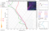
@ashtonlemleywx I think you picked a good spot to chase I think near that west Mississippi area near the state line you'll have a good chance at some potentially tornadic storms. Wouldn't surprise me for a enhanced and a small 10% area near there. 2023011721_RAP_021_33.18,-90.81_severe_ml.png
 
Last edited:
I actually think the ones further southwest of it closer to the line are the better parameters.

If one of these cells or the broken line itself can shift more towards a eastward motion it'd help in the tornado threat

storm north of nacogdoches, tx is starting to curl up, not to mention it has maintained a noticeable couplet for several scans now.
 
storm north of nacogdoches, tx is starting to curl up, not to mention it has maintained a noticeable couplet for several scans now.
It will continue to enter a better environment. Those cells will be the ones to produce the stronger nados, I mentioned in the post to Kevin the ones southwest of the current isolated stuff in Arkansas will have a better chance. Instability on the rise ahead of it as well as shear.
 
DAY 1 CONVECTIVE OUTLOOK
NWS STORM PREDICTION CENTER NORMAN OK
1030 AM CST WED JAN 18 2023

VALID 181630Z - 191200Z


...THERE IS A SLIGHT RISK OF SEVERE THUNDERSTORMS SABINE AND LOWER
MS/OH VALLEYS...

..SUMMARY


A FEW TORNADOES AND SCATTERED DAMAGING WINDS REMAIN POSSIBLE THIS
AFTERNOON FROM THE SABINE VALLEY TO THE MID-SOUTH, WITH MORE
ISOLATED COVERAGE CONTINUING INTO THIS EVENING ACROSS THE LOWER OHIO
AND MISSISSIPPI VALLEYS.

..SABINE AND LOWER MS/OH VALLEYS


MINIMAL CHANGE APPARENT FOR THIS OUTLOOK WITH A BROKEN BAND OF
THUNDERSTORMS WITHIN THE WARM CONVEYOR AHEAD OF THE EASTERN-MOVING
COLD FRONT. THE SEVERE THREAT WILL LIKELY PEAK THIS AFTERNOON FROM
THE SABINE VALLEY INTO THE MID-SOUTH WHERE 60S SURFACE DEW POINTS
(INCREASING TO THE SOUTHWEST) SUPPORTS MLCAPE OF 500-1000 J/KG. THE
ORIENTATION AND TRACK OF THE SHORTWAVE TROUGH OVER THE CENTRAL GREAT
PLAINS SUGGESTS THAT MID-LEVEL LAPSE RATES WILL WEAKEN THIS
AFTERNOON, ALONG WITH INCREASINGLY VEERED LOW-LEVEL FLOW DIMINISHING
HODOGRAPH CURVATURE OVER THE SOUTHERN PORTION OF THE CONVECTIVE
THREAT IN TX/LA. THIS WILL LIKELY MAINTAIN STP VALUES IN THE 1-2
RANGE THIS AFTERNOON BEFORE DIMINISHING LATER. A FEW TORNADOES
APPEAR POSSIBLE, WITH THE DAMAGING WIND THREAT INCREASING SOME AS
THE BROKEN LINE CONSOLIDATES INTO A BROADER QLCS.

CONFIDENCE IS DECREASING WITH THE LONGEVITY OF AN APPRECIABLE
TORNADO AND WIND THREAT BEING MAINTAINED THIS EVENING. BULK OF
MORNING CAM AND MACHINE-LEARNING GUIDANCE ARE INSISTENT ON
DIMINISHING CONVECTIVE INTENSITY TOWARDS 00Z, DESPITE STRENGTHENING
OF THE SOUTH-SOUTHWESTERLY LOW-LEVEL JET. SURFACE-BASED INSTABILITY
SHOULD EVENTUALLY BECOME PINCHED OFF IN THE MID-SOUTH THROUGH
EASTERN MS AFTER SUNSET. THIS SETUP APPEARS LIKELY TO YIELD A
DECREASING, BUT STILL A PERSISTENT LOW PROBABILITY WIND/BRIEF
TORNADO THREAT LINGERING TONIGHT.

..SOUTHEAST KS


AS THE SHORTWAVE TROUGH MOVES EAST ACROSS KS, A SMALL CORRIDOR OF
OPPORTUNITY FOR SURFACE HEATING AND STEEPENING LOW-LEVEL LAPSE RATES
IS POSSIBLE NEAR AND EAST-SOUTHEAST OF THE ASSOCIATED SURFACE
CYCLONE, BENEATH THE MID-LEVEL DRY SLOT. IN THE WAKE OF MORNING
RAINFALL, THERE MAY BE SCANT MLCAPE APPROACHING 250 J/KG. THIS COULD
BE BARELY ADEQUATE FOR A LOW-TOPPED SUPERCELL WITH SMALL TO
MARGINALLY SEVERE HAIL AND A BRIEF WEAK TORNADO POSSIBLE.

spccoday1.categorical.latest.png
 
Back
Top