Navigation
Install the app
How to install the app on iOS
Follow along with the video below to see how to install our site as a web app on your home screen.
Note: This feature may not be available in some browsers.
More options
-
Welcome to TalkWeather! We see you lurking around TalkWeather! Take the extra step and join us today to view attachments, see less ads and maybe even join the discussion. CLICK TO JOIN TALKWEATHER
You are using an out of date browser. It may not display this or other websites correctly.
You should upgrade or use an alternative browser.
You should upgrade or use an alternative browser.
Severe WX Severe Weather Threat Jan 12th, 2023
- Thread starter KevinH
- Start date
Already supercellular,, the line today will be semi broken with supercells inside the lineIs it trying to form a hook and maybe going super cellular?
- Moderator
- #244

Newest SPC disco for the SE.
Farther south, the primary severe threat today is expected to evolve
from the storms forming in MS this morning. This convection is
aligned along the leading edge of the baroclinic zone near 700 mb,
which is currently ahead of the remnant lee trough/cold front.
Storms in this corridor will likely increase through the day in
response to continued moisture advection from the south and surface
heating in cloud breaks. Moderate buoyancy (MLCAPE of 1000-1500
J/kg), strong deep-layer shear/long hodographs, and some low-level
hodograph curvature (effective SRH in excess of 200 m2/s2) will
favor a mix of supercells and bowing segments in a band a little
ahead of the surface cold front through the afternoon. Damaging
winds will be the most common threat, and semi-discrete supercells
in the band will pose the threat for tornadoes, along with embedded
circulations in line segments. The stronger storms in the band will
also be capable of producing large hail, generally in the 1-1.5 inch
diameter range. The storms will spread eastward across GA and into
the Piedmont of the Carolinas by early tonight, before weakening as
the convection outpaces the unstable warm sector.
xJownage
Member
SFC winds have backed far more than expected. That combined with a little more warm air advection than expected is making this a much more significant event than it appeared yesterday.
- Moderator
- #247
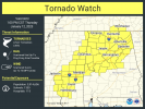
I don't like the probs on that watch! 
Probability of 2 or more tornadoes: high 70%
Probability of strong: mod 30%
Probability of 2 or more tornadoes: high 70%
Probability of strong: mod 30%
Long day incoming lol.I don't like the probs on that watch!
Probability of 2 or more tornadoes: high 70%
Probability of strong: mod 30%
- Thread starter
- #250
KevinH
Member
And this is partially why people say Dixie is sneaky lolSFC winds have backed far more than expected. That combined with a little more warm air advection than expected is making this a much more significant event than it appeared yesterday.
xJownage
Member
One of the things that may save us from more significant tornadoes is the presence of some decently strong VB with an inflection point below or around 2km. Research shows that VB below 3km favors rapid cycles when compared to environments when the inflection point of VB is above 3km.
More southerly than backed, but even so favorable tornadic environment, any more significant backing and it'd be a pretty good threat.SFC winds have backed far more than expected. That combined with a little more warm air advection than expected is making this a much more significant event than it appeared yesterday.
Timhsv
Member
0-1KM is not shabby this A.M.


Once the line gets to near Tuscaloosa and starts to break up a bit more, your tornado threat should really bump up, as forecast updraft really kicks off then.
- Thread starter
- #255
KevinH
Member
Thanks…. I think lolOnce the line gets to near Tuscaloosa and starts to break up a bit more, your tornado threat should really bump up, as forecast updraft really kicks off then.
xJownage
Member
backed doesn't mean SE, backed just means turning counter-clockwise to what's expected. The wind going from SW to S is still backing.More southerly than backed, but even so favorable tornadic environment, any more significant backing and it'd be a pretty good threat.
JBishopwx
Member
Confirm damage in Monroe County.
- Thread starter
- #258


