
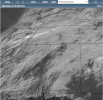
15z hrrr run chose violence over your area, a lot of longer tracked supercells /rotation.I noticed that too.

Last edited:
Follow along with the video below to see how to install our site as a web app on your home screen.
Note: This feature may not be available in some browsers.
15z hrrr run chose violence over your area, a lot of longer tracked supercells /rotation.I noticed that too.

.gif")
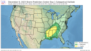
...Gulf Coast/Lower Mississippi Valley/Tennessee Valley...
Region is being increasingly influenced by height falls but
otherwise resides between larger scale influences of an upper trough
over the Upper Midwest and a positive-tilt trough over the southern
High Plains. Increasing warm-sector moisture (generally lower to
some middle 60s F surface dewpoints) ahead of a southeastward-moving
cold front, along with considerable deep-layer/low-level shear, will
be favorable factors for a long-duration severe risk through the
afternoon into tonight. However, the likelihood of a complex/mixed
quasi-linear convective mode casts uncertainty regarding the
magnitude of the severe risk, particularly regarding a
supercell-related sustained/focused tornado risk. It is also noted
that some guidance suggests that 1-3km AGL winds may somewhat weaken
by late afternoon/early evening within the warm sector, while noting
SRH will still remain favorable for rotating/severe storms.
Storms should continue to increase in coverage through early
afternoon, initially near the front across Arkansas northeastward
into western portions of Tennessee/Kentucky. Sufficiently steep
mid-level lapse rates will support some hail potential, especially
the first part of the day, but the tendency for storm clustering
will otherwise limit this overall potential, as well as limiting
prospects for more consequential hail magnitudes. As the boundary
layer warms this afternoon, the potential for initially
semi-discrete supercells will increase along with related damaging
wind risk as well as tornado potential, which will persist through
the afternoon/evening even with a quasi-linear convective mode.
As warm-sector inhibition further weakens later this afternoon,
additional deepening convection may develop within weak pre-frontal
convergence/confluence regime, mainly across Mississippi into
Alabama, with this development eventually merging with or taking
over as the main convective band this evening. Similarly,
pre-frontal confluence may support isolated supercellular
development along the Gulf Coast/Florida Panhandle vicinity through
late night hours/early Sunday, within a somewhat separate regime
capable of a few severe storms.
Yeah, I'd treat the day with caution wether it is slight or enhanced.SPC could still do a special upgrade, but I can see why they're hesitant. Regardless though gonna be interesting to see how it plays out. We've already hit 70 degrees.
The sun is putting in some work. Up 3°Sun is out here in Cullman. Up to 65/64
I'm not buying it in/around the Memphis area yet. Northeast Ms/NW Alabama is another storyIf model trends hold, today would probably be a good day to pull out the unhatched 10%. Regardless, everyone in MS and AL should be on their toes this evening.
Too close for comfort.16Z HRRR continuing the trend of pretty aggressive UH streaks (only halfway in so far).
View attachment 22400
That's where my guess would be as well. But I've seen weirder things before.I'm not buying it in/around the Memphis area yet. Northeast Ms/NW Alabama is another story
It seems like CAMs sometimes over-estimate what happens in west TN, though as to why that happens I've no clue.I'm not buying it in/around the Memphis area yet. Northeast Ms/NW Alabama is another story

.png")