Severe WX Severe Weather Threat - December 8th-10th, 2023

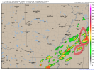
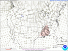
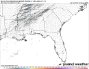
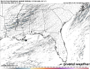
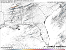
Current HRRR run is real bullish on supercells in central Alabama.

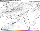
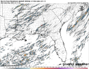
I would not be shocked at all for a small localized enhanced later on today somewhere, definitely not central Alabama but, EVERYBODY should be on there toes if you live from central Alabama into central Mississippi and north into Tennessee
 
Currently getting rained on right now. Let's see how this atmosphere plays out today, if instability is ahead of schedule or even more bullish into central Alabama and Alabama in general or what not, that could throw a wrench into things.
 
Last post for this morning after getting up and looking at a few model runs. Just a few takeaways worth watching as we progress through the morning.

- HRRR runs are becoming bullish on discrete / semi discrete supercells spawning around central Alabama / west central Alabama around late afternoon (maybe it will just be hailers and some damaging wind, but needs to be watched)

-The main line in general appears to be semi broken giving more credence to possibly a longer lived tornado given the right circumstances, and on top of that supercells forming ahead of it.

-Newer HRRR runs slowly keep ticking up shear in north Alabama into central Tennessee even before the nocturnal jet increases.

Do not let this event sneak up on you guys. Maybe it busts? Maybe it booms?
 
Last edited:
I know nothing about the technical end of this forum, but mods/admins, can someone check and make sure we don't go down when things get going? Lots of people having issues getting on. I had a problem myself last night and one of my friends that doesn't post just told me she's having problems this morning. Thanks so much!
 
Here in Smithville, MS the temperature is already at 67 (max high is 70) with a dewpoint of 64.
 
Here's all the latest max updraft helicity output.
 

Attachments

  • uh25_max.us_se (6).png
    uh25_max.us_se (6).png
    309.4 KB · Views: 0
  • uh25_max.us_se (5).png
    uh25_max.us_se (5).png
    450.1 KB · Views: 0
  • uh25_max.us_se (4).png
    uh25_max.us_se (4).png
    384.3 KB · Views: 0
  • uh25_max.us_se (3).png
    uh25_max.us_se (3).png
    361 KB · Views: 0
  • uh25_max.us_se (2).png
    uh25_max.us_se (2).png
    499 KB · Views: 0
  • uh25_max.us_se (1).png
    uh25_max.us_se (1).png
    365.6 KB · Views: 0
Here in Smithville, MS the temperature is already at 67 (max high is 70) with a dewpoint of 64.
70/64 here in Ackerman
 
Clip from SPC Day 1:

The tornado and wind threats should be relatively maximized from the
Mid-South to Tennessee Valley region, given that area's probable
overlap between the most favorable parameter space and thunderstorm
probability. However, concerns over storm morphology --
particularly potential for messy/embedded convective modes and short
duration of favorably mature supercell/mesocyclone production --
remain large. This notion is supported by the presence of short,
low- to medium-magnitude UH tracks in the preponderance of CAM
guidance. This does not preclude the possibility of a significant
or longer-lived tornado threat locally, but makes it too conditional
and uncertainly focused for a specific, greater-potential outlook
area at this point
 
Looking at the latest FV3 run, there were two storms being depicted that caught my attention. Both have that tornado look. By the way on the latest SIG TOR run, the 45 contour is now further south.
 

Attachments

  • index (1).png
    index (1).png
    339.9 KB · Views: 0
  • SREF_prob_combined_sigtor__f015.gif
    SREF_prob_combined_sigtor__f015.gif
    56.4 KB · Views: 0
Back
Top