• Welcome to TalkWeather!
    We see you lurking around TalkWeather! Take the extra step and join us today to view attachments, see less ads and maybe even join the discussion.
    CLICK TO JOIN TALKWEATHER

Severe WX Severe Weather Threat 4/5/17-4/6/17

This.

I am not overly enthusiastic about events that rely entirely on mesoscale kinematics to verify. I've seen far too many potent setups that seem to have everything going for them end up underperforming due to other compensating factors simply not being enough to make up for a bad wind profile. For anyone expecting everything on the radar to be spinning like crazy once round 2 starts, I'd temper your expectations a bit. We may see a lot of cells that end up not doing too much, with just a few going nuts due to boundary interactions. Just my two cents.

Those are my feelings as well, especially for areas IMBY (Central AL). Think hail may be the main story here unless the winds become more favorable this afternoon.
 
It's gonna take some mesoscale boundaries today. Critical angles are not favorable as of NOW.

True. What are you using for surface analysis?
 
Those are my feelings as well, especially for areas IMBY (Central AL). Think hail may be the main story here unless the winds become more favorable this afternoon.

It may be one of those count you blessings type of days, where everything is spinning yet no ground truth. Now GA on the other hand will have problems when the LLJ kicks up this evening and spiked helicity. That is the thing to watch, when does the LLJ spike.
 
So is there going to be a second round that develops or did that MCS cause too much disruption?
 
We are waiting on an update from HUN shortly. I am looking at the temporary reporting sites set up across N AL/S TN and see dewpoints in the 62-64 range have made it to the TN River area now.
 
We are waiting on an update from HUN shortly. I am looking at the temporary reporting sites set up across N AL/S TN and see dewpoints in the 62-64 range have made it to the TN River area now.

Yeah mesoanalysis shows instability going up very fast behind the storms as they push east.
 
GOES-16 is pretty awesome. Just sayin'


Thank God they are looking to cut over 600 million from NOAA -- with the biggest cuts to the satellite division. Much, much, much easier just to lick your finger and hold it up and see which way the wind is blowing. All that is needed.
 
From my perspective, it sure seems like the event is over for areas west of a line from Cullman to Jasper to Tuscaloosa to Meridian MS.
 
From my perspective, it sure seems like the event is over for areas west of a line from Cullman to Jasper to Tuscaloosa to Meridian MS.
I don't know if I'd say that. I still think we'll get isolated supercells along the dry line this afternoon. Question is, will there be enough to get them rotating or will we just be dealing with hail...
 
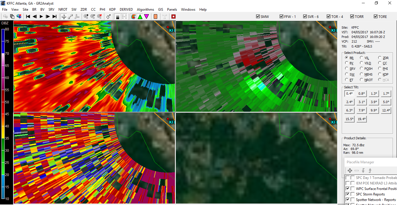
Tornado Warning - Southern Fayette, East Central Cowetta County in GA. Pretty much right over FFC radar site ..... Argghhhhh
 
there's a LOT of contamination, but right over KFFC there may be a tornado, evidence of a really closeup couplet (spread slightly because of proximity) and some CC.
28baeb5abf6c390b6417a51e1c51db8a.png

this is the scan that caught my eye. looks a lot like some other really close-proximity tornadoes.

appears to be a brief spin-up, as it's now gone
 
If KFFC gets hit by a tornado and also goes down for the day, we're utterly screwed.
 
Back
Top