- Staff
- #161
Oops!! Sorry y’all!!W
rong thread")
Follow along with the video below to see how to install our site as a web app on your home screen.
Note: This feature may not be available in some browsers.
Oops!! Sorry y’all!!W
rong thread
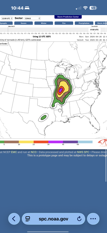
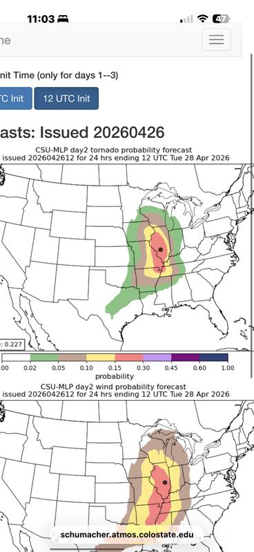
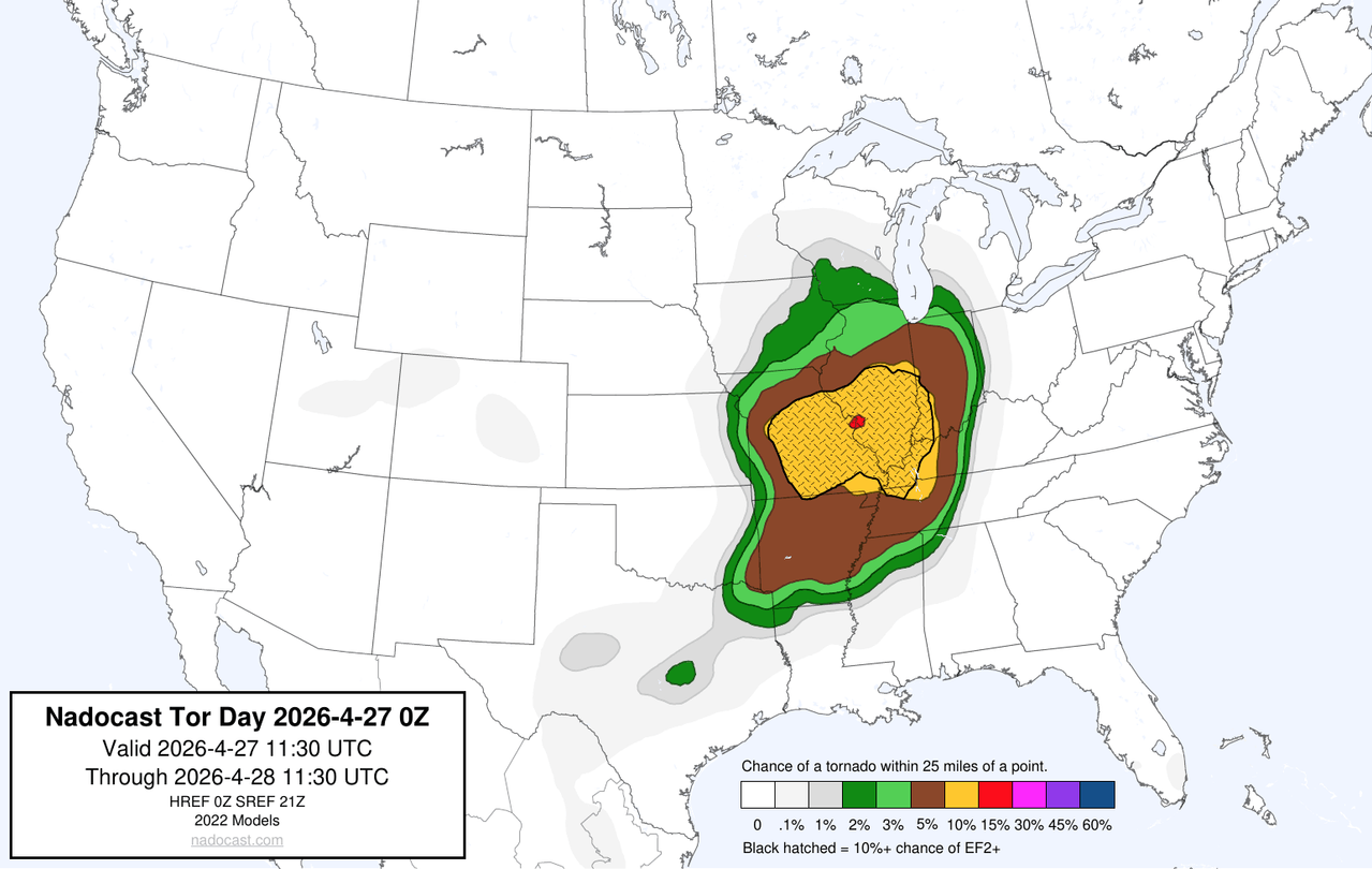
for tomorrow night?Well, after seeing the 00z HRRR and more specifically, the 00z RRFS, I am convinced that more of North MS needs to be upgraded to Level 2 or 3 risk for tomorrow.
Yes. They might wait until then or just go ahead with it. However, this Marginal Risk ain't gonna cut if that verifies.for tomorrow night?
Think the southern. End is being over looked …Yes. They might wait until then or just go ahead with it. However, this Marginal Risk ain't gonna cut if that verifies.
I've been saying that ever since they pulled the bulk of the highest risk northward. LOL!Think the southern. End is being over looked …

I like that he is somewhat skeptical instead of just totally saying the midwest is getting vaporized tomorrow. I kind of wonder if Max's degree has ironically just made him kind of arrogant in comparison.Ryan Hall reacting live to 00z HRRR now. Pretty interesting.
Edit: He thinks morning convection will probably last longer than is being shown currently, but if it actually plays out how the HRRR is showing right now it'll be a big memorable tornado outbreak. He said it reminds him of another memorable outbreak, but he wouldn't say which one. I thought that was pretty respectable given all the hypecaster analogs constantly being thrown around these days.
It seems like the ensemble, deterministic, and AI models haven't wavered a single time for the last 5 days that tomorrow will be a severe weather outbreak. If you don't issue a moderate for this, then what do you issue it for? There's almost always morning convection with big multi day sequences like this, and the most severe days of those sequences are almost always in the second half. Sure, storm mode is a question mark, but the synoptics are saying it's not that pertinent.Even without these recent doom runs from the models, I still think tomorrow would warrant a MOD. I’d be surprised if they didn’t issue it when the new D1 comes out.
The crapvection should be able to clear because of the very fast jet translation speed; that’s part of the reason why it is so good for tornado outbreaks in the first place. But if many of the models still have a bunch of garbage and morning convection tempering the environment substantially, and visible satellite tomorrow looks not great for a significant event, ENH is the correct call. I think erring on the side of caution here is smart for many reasons, but this event can definitely hit a nasty gear if it plays its cards right.It seems like the ensemble, deterministic, and AI models haven't wavered a single time for the last 5 days that tomorrow will be a severe weather outbreak. If you don't issue a moderate for this, then what do you issue it for? There's almost always morning convection with big multi day sequences like this, and the most severe days of those sequences are almost always in the second half. Sure, storm mode is a question mark, but the synoptics are saying it's not that pertinent.