
Muwx
Member
It was almost certainly in the ground 5-10 minutes ago.Where did you see this? Nothing notable on radar, warning isn't even observed.
Follow along with the video below to see how to install our site as a web app on your home screen.
Note: This feature may not be available in some browsers.
It was almost certainly in the ground 5-10 minutes ago.Where did you see this? Nothing notable on radar, warning isn't even observed.
ax velocity spin up qclsWhere did you see this? Nothing notable on radar, warning isn't even observed.
It was almost certainly in the ground 5-10 minutes ago.
Looks like there was a brief touchdown at about 7:52 visible for only one scan. Sneaky little bugger. Good catch.M
ax velocity spin up qcls
Honestly it’d be hard not to. There’s a conditional strong tornado threat tomorrow. Even if there’s a couple weaker ones that’s outperforming whatever this was, 100% on the table.Watch tomorrow perform more than today. Maybe lol..
This is one of the biggest busts I can recall tracking in my 15 years of following events closely. 5/20/2019 may still hold that mantle for me, but many of us thought the floor for this event was at least a few intense tornadoes across the highest risk areas today and we may not have had a single tornado happen during the PDS watch period.I really thought that the Poplar Bluff storms were going to look better when they got closer to the radars, but no. They look like slop. Today was a prime example of a true bust.
I certainly consider it the biggest bust I’ve tracked, including 4/28 last year. Although, I don’t have nearly as much experience as many others here, so it’s not really saying a lot.This is one of the biggest busts I can recall tracking in my 15 years of following events closely. 5/20/2019 may still hold that mantle for me, but many of us thought the floor for this event was at least a few intense tornadoes across the highest risk areas today.
The Mountain View, AR storm should get a tornado warning imminently. There’s a pretty tight couplet developing on it.
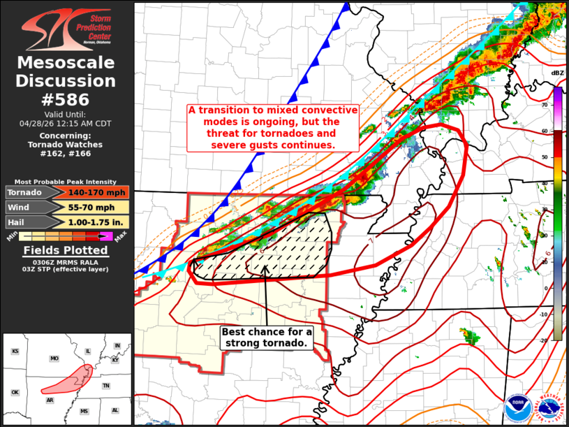
Mesoscale Discussion 0586
NWS Storm Prediction Center Norman OK
1009 PM CDT Mon Apr 27 2026
Areas affected...northern Arkansas...southeast Missouri...and far
western Kentucky
Concerning...Tornado Watch 162...166...
Valid 280309Z - 280515Z
The severe weather threat for Tornado Watch 162, 166 continues.
SUMMARY...A transition to a mix of convective modes is ongoing.
While the potential for severe hail may be decreasing, the threat
for tornadoes and severe winds continues.
DISCUSSION...Regional reflectivity data shows gradual upscale growth
across north-central AR as new convection develops along a cold
front. Initially semi-discrete supercells across southern MO have
recently shown some signs of weakening and/or poor organization -
likely the result of being displaced behind an outflow boundary,
which is becoming more apparent in velocity imagery. Further
southwest, convective clusters and semi-discrete supercells continue
to develop across north-central AR.
This activity continues to spread east into a very favorable
environment for organized convection with KLZK and KNQA VWPs now
sampling 0-1 km SRH between 450-500 m2/s2. The loss of discrete
supercells should modulate the potential for very large hail to some
degree, but even with a transition to a mix of convective bands and
embedded supercells, the environment will support the potential for
tornadoes (potentially strong) and swaths of severe winds. Latest
high-res guidance, including recent WoFS ensemble runs, suggest that
the greatest tornado/severe wind threat will reside across northern
AR and southeast MO into adjacent portions of IL, TN, and KY over
the next couple of hours.
..Moore.. 04/28/2026
170 max on this is nasty work lmfao
It would be very 2026 for there to be a random strong tornado along this portion of the line, at this time during the event. Also, I would post a picture but cannot, the Mountain View, AR storm does genuinely have the best velocity couplet I’ve seen all day on a supercell.170 max on this is nasty work lmfao
Yep Mountain View storm wrapping up ..It would be very 2026 for there to be a random strong tornado along this portion of the line, at this time during the event. Also, I would post a picture but cannot, the Mountain View, AR storm does genuinely have the best velocity couplet I’ve seen all day on a supercell.