- Moderator
- #361
I wish we could hurry up and get someone with a live stream on the Knox city tornado.
Follow along with the video below to see how to install our site as a web app on your home screen.
Note: This feature may not be available in some browsers.
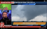
   SUMMARY...Pair of potentially long-lived supercells within the
   southern portion of WW 146 may evolve with an intense tornado and
   very large hail threat.

   DISCUSSION...A potentially long-lived, slow-moving discrete
   supercell is centered over Knox County, TX. This supercell appears
   to be anchored along the far southern portion of the broader
   convective plume that extends north across OK/KS. With full
   insolation in the warm-moist sector inflow to its southeast, its
   plausible that a long-lived supercell will persist for the next 2-3
   hours. Amid MLCAPE of 3000 J/kg and mid 60s surface dew points to
   its southeast, a cyclic tornadic supercell could evolve beyond the
   very large hail threat with up to baseballs reported thus far. The
   supercell to its northeast in Wilbarger County, TX will also have
   potential to further intensify as it spreads towards and northwest
   of the Wichita Falls vicinity, given 0-1 km SRH of 100-200 m2/s2 per
   FDR VWP data.
And to be fair to today, the 20z outlook text made it clear that we're only lingering storm mode/interaction questions away from them having pulled the trigger on a High Risk upgrade as is.With the introduction of enhanced as an option for lower end moderate days, it feels like highs are now reserved for clear cut historical outbreak days lacking enough uncertainty to preclude any questions, which is probably fine; barring extreme historical outbreaks like 4/27/11 or 5/3/99 most of our violent tornadoes have usually been on conditional risk days much lower than high anyway. We used to have an insane number of moderate and high busts in the 00s and early 10s so I'm kinda glad the threshold is now so ridiculously high.
Thank you so much!Just wanted to say it’s nice to see Fred active on the forum. Such a quality asset to the site. Thanks Fred for all your insight. You all at tn valley weather do a great job!
I guess it is easier to track and post when the storms aren't in your coverage area!Thank you so much!

Just went TORR a second ago.T.O.G. Stillwater storm.
...A TORNADO WARNING REMAINS IN EFFECT UNTIL 400 PM CDT FOR EASTERN
NOBLE COUNTY...
At 330 PM CDT, a confirmed tornado was located 4 miles west of
Morrison, moving north at 45 mph.
HAZARD...Damaging tornado and quarter size hail.
SOURCE...Weather spotters confirmed tornado.
IMPACT...Flying debris will be dangerous to those caught without
shelter. Mobile homes will be damaged or destroyed. Damage
to roofs, windows, and vehicles will occur. Tree damage is
likely.
Locations impacted include...
Morrison and Sooner Lake.