- Moderator
- #341
Tornado confirmed by weather spotters near Knox City, TX.
Follow along with the video below to see how to install our site as a web app on your home screen.
Note: This feature may not be available in some browsers.
Honestly man at this point who cares, what matters with the public has been hammered home on all channels.No high risk today…
Day 1 Convective Outlook
NWS Storm Prediction Center Norman OK
0300 PM CDT Sat Apr 27 2024
Valid 272000Z - 281200Z
...THERE IS A MODERATE RISK OF SEVERE THUNDERSTORMS OVER PARTS OF
THE SOUTHERN AND CENTRAL PLAINS...
...SUMMARY...
Severe thunderstorms are likely today and tonight across the
southern and central Plains into the lower to mid Missouri Valley.
The most numerous/intense storms are expected from north Texas into
Oklahoma and southeast Kansas, where strong tornadoes, very large
hail of 2-3 inches in diameter and damaging winds of 60-80 mph are
all possible.
...20z Update...
The previous forecast remains on track for a regional outbreak of
severe storms with strong, potentially long-track tornadoes, very
large hail and damaging winds. Numerous storms have initiated within
the warm sector ahead of the dryline over central KS and much of OK.
Numerous supercells are present, but storm organization has been
slow thus far. As the boundary-layer slowly deepens from strong
southerly warm air advection and muted diurnal heating, an
increasingly strong low-level jet will gradually expand low-level
hodographs. Multiple rounds of convection appear likely through
tonight as the main trough is still forecast to overspread the
southern Plains from 21-06z. While some uncertainty about storm mode
and interactions limits predictability for higher tornado probs, the
environment remains favorable for strong and potentially long-track
tornadoes and very large hail with the more discrete supercells into
tonight.
...Northern KS and southern NE into MO and IA...
The cold front/effective boundary has trended farther south than the
most recent guidance. Additional storm development to the south
should further reinforce this boundary through the day. Hail and a
few tornadoes appear likely with supercells along the warm side of
the front. Have adjusted the ENH southward to better account for
ongoing storms.
Farther east, clear skies and strong low-level moisture advection
have allowed for substantial destabilization over parts of northern
MO and southern IA. South of the effective front, additional storm
development into lines and clusters appears likely into the
afternoon. Damaging winds and a few tornadoes are likely.
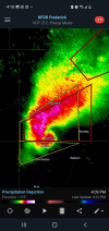
..Lyons.. 04/27/2024


At 312 PM CDT, a confirmed large and extremely dangerous tornado was
located over Knox City, moving northeast at 25 mph.
This is a PARTICULARLY DANGEROUS SITUATION. TAKE COVER NOW!
Bingo. Couldn’t have said it better myself. To us enthusiasts, that pink high risk means a big day, maybe one of the big ones. To EMAs and WFOs it’s all hands on deck with personnel movements and prep. I’m sure gearing up for a Atmospheric Anti-Climax high over and over would cause some complacency that when the real day comes, well…With the introduction of enhanced as an option for lower end moderate days, it feels like highs are now reserved for clear cut historical outbreak days lacking enough uncertainty to preclude any questions, which is probably fine; barring extreme historical outbreaks like 4/27/11 or 5/3/99 most of our violent tornadoes have usually been on conditional risk days much lower than high anyway. We used to have an insane number of moderate and high busts in the 00s and early 10s so I'm kinda glad the threshold is now so ridiculously high.
Chris Hall reporting rotating rain curtains on the Stillwater storm.