• Welcome to TalkWeather!
    We see you lurking around TalkWeather! Take the extra step and join us today to view attachments, see less ads and maybe even join the discussion.
    CLICK TO JOIN TALKWEATHER
  • April 2024 Weather Video of the Month
    Post your nominations now!
Logo 468x120

Severe Weather Threat 4/27-4/28, 2024 - (Saturday, Sunday)

UK_EF4

Member
Messages
573
Reaction score
1,329
Location
NW London
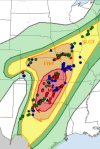
Today looks unfortunately like a potentially nasty day as well. Hadn't even realised until this morning being so focused on both the 26 and 27 outbreaks - but the environment does look to become arguably supportive of strong-intense tornadoes this afternoon/evening in parts of E TX, OK and AR.

1714303909908.png

Luckily the threat looks to highly depend on how much surface destabilisation occurs behind the current morning MCS from last nights storms - and also how much of a discrete mode there would be. Generally looks quite messy so hopefully we wont see anything able to utilise the above environment, but will be on the lookout for trends through the day which may change the threats magnitude.
 

TheSuckZone

Member
Messages
357
Reaction score
773
Location
Kansas
I've yet to see any confirmed reports of fatalities from either outbreak in this sequence so far. Assuming that holds true, if that's not a testament to the overall warning process and the public response to it given the ferocity of what has happened, then I don't know what is. Even with today's technology, Friday alone easily could've been a day with dozens of fatalities, not to mention the after dark significant tornadoes striking towns in southern Oklahoma on Saturday evening...
That would be a miracle and I pray that holds true
 

joshoctober16

Member
Messages
155
Reaction score
119
Location
Canada New brunswick
I’m talking about the actual top tier outbreaks…for what it was…yesterday’s outbreak was still far from what you would class as “historic”…no where near the likes of…

March 13 1990
April 26 1991
May 3rd 1999
May 24 2011

Ya know…those kind’s of outbreaks
Where actual extremely violent damage was done…
The last tornado to produce objectively violent damage in the plains was matador…and that was one fluke tornado on an otherwise middling day…

It seems like top tier set-ups just don’t do anything notable in the classic plains way anymore…
note historic outbreaks are the level right under super outbreak, the last one to happend (note not counting this outbreak since it cant yet be calculated) was march 31 2023
 

wx_guy

Member
Messages
281
Reaction score
815
Location
United States
HAM Callsign
KO4ZGH
Special Affiliations
  1. SKYWARN® Volunteer
  2. ARRL Member
Wow, I went to bed at the wrong time last night, all hell broke lose....


Curious about the horrible training of tornadic supercells and how that plays into the rating -- if Sulphur (for instance) was hit by overlapping tracks, is the overlap totally contaminated data-wise to rate any of the tornadoes? I mean how can you attribute damage X to tornado A if tornadoes B and C followed? Interesting conundrum of the way the EF scale is set up to rate based on damage with it being an indirect indicator and all.
 

A Guy

Member
Messages
179
Reaction score
366
Location
Australia
So yeah, definitely don’t see any “entire town gone” Greensburg level damage.

But it’s to say Sulpher won’t be the same after this, big section of town has to be replaced.
It's a mildly irritating bit of hyperbole, like this one from yesterday from Minden - town looks there and later chaser and drone footage showed the tornado hit the edge. The highly damaging core is much rarely more than a couple of hundred metres outside of extreme cases, many towns are bigger. Obviously in this case a lot of buildings will still have to go and lot of money will still have to be spent.

It'd one of those storm chaser/tornado enthusiast exaggeration things. A bit like with size - a survey may have EF0 contour a half mile wide or whatever, the actual condensation funnel they're seeing will probably be less than what they're saying in their videos. Or the use of 'violent' to describe anything more than a little spin up.
 
Last edited:

Xanthaar

Member
Messages
9
Reaction score
21
Location
UK
It's a mildly irritating bit of hyperbole, like this one from yesterday from Minden - town looks there and later chaser and drone footage showed the tornado hit the edge. The highly damaging core is much rarely more than a couple of hundred metres outside of extreme cases. Obviously in this case a lot of buildings will still have to go and lot of money will still have to be spent.

Seems to be one of those storm chaser/tornado enthusiast exaggeration things. A bit like with size - a survey may later put an EF0 contour at a half mile wide or whatever, the actual condensation funnel they're seeing will probably be less than what they're saying in their videos.
It's more than mildly irritating. It's downright scummy to do. People who say this care more about their social media interactions than the response to these disasters. It's imperative that EMS get accurate information in the immediate aftermath of such scenarios. If people go around saying entire towns have been wiped out, it will likely result in redirected first response from other areas impacted. Any relatives of people in the town hit are likely to presume the worse for their loved ones too when they inevitably search social media for updates and see that the entire town is "gone", causing all sorts of unnecessary anguish. I really wish the community would call out chasers who overexaggerate impacts like this.
 

Gail

Member
Messages
412
Reaction score
602
Location
Caledonia, MS
I spent the day with my Weather Airman son yesterday, and I didn’t have the best service. Someone sent him a text saying there were 8-9 PDS tornado warnings at the same time?!? That sounds insane. It was a horrible two days for some residents of the Midwest. Heartbreaking.
 

Muwx

Member
Messages
201
Reaction score
362
Location
Republic Mo
I spent the day with my Weather Airman son yesterday, and I didn’t have the best service. Someone sent him a text saying there were 8-9 PDS tornado warnings at the same time?!? That sounds insane. It was a horrible two days for some residents of the Midwest. Heartbreaking.
A lot of warnings were getting PDS tags with nothing confirmed.
 

Tanner

Member
Messages
426
Reaction score
770
Location
Granville, MA

Equus

Member
Messages
3,346
Reaction score
3,532
Location
Jasper, AL
Special Affiliations
  1. SKYWARN® Volunteer
That nocturnal round was terrifying; got busy and barely checked up on it but reviewing everything this morning that was a horrifying night for a lot of Oklahoma. Looks like the some of the worst happened in the radar hole only kinda filled by the Durant radar. We definitely got the right balance between dynamics for supercells to do this and too much forcing just way later in the day than I expected. Some really violent damage out there

Given the distribution of tornado reports, looks like the moderate verified almost perfectly; didn't verify in the daytime isolated supercell category as expected but managed to spam strong long tracked tornadoes on the tail end of the expected time frame anyway
 
Last edited:

Tanner

Member
Messages
426
Reaction score
770
Location
Granville, MA
That nocturnal round was terrifying; got busy and barely checked up on it but reviewing everything this morning that was a horrifying night for a lot of Oklahoma. Looks like the some of the worst happened in the radar hole only kinda filled by the Durant radar. We definitely got the right balance between dynamics for supercells to do this and too much forcing just way later in the day than I expected. Some really violent damage out there

Given the distribution of tornado reports, looks like the moderate verified almost perfectly; didn't verify in the daytime isolated supercell category as expected but managed to spam strong long tracked tornadoes on the tail end of the expected time frame anyway
*VERIFIED* ✅
 

Attachments

  • IMG_3818.jpeg
    IMG_3818.jpeg
    165.7 KB · Views: 0
Back
Top