- Moderator
- #1
Multi day severe weather pattern that has been on the models for weeks.
Follow along with the video below to see how to install our site as a web app on your home screen.
Note: This feature may not be available in some browsers.

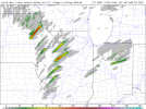
Day 2 Convective Outlook
NWS Storm Prediction Center Norman OK
0100 AM CDT Fri Mar 27 2020
Valid 281200Z - 291200Z
...THERE IS A MODERATE RISK OF SEVERE THUNDERSTORMS FOR PORTIONS OF
NORTH-CENTRAL AND NORTHWEST ILLINOIS...
...SUMMARY...
A significant severe weather outbreak is possible for portions of
the middle Mississippi Valley on Saturday. The threats with the
stronger storms include tornadoes, a few which may be significant,
large to very large hail, and severe gusts.
...Synopsis...
An intense 150-kt upper speed max over the southern Great Plains
Saturday morning will quickly move into the middle MS Valley by mid
afternoon, as a northeast-migrating mid-level low moves from the
central High Plains into the Upper Midwest. An intense belt of
southwesterly 500mb flow (100+ kt) will concurrently move from OK
into IL by Saturday evening and into the southern Great Lakes by
early Sunday morning. A 990mb surface low will develop northeast
and deepen further into north-central IA by early evening before
becoming occluded over WI by daybreak Sunday.
...Mid MS Valley...
---Confidence is increasing for a potentially potent severe weather
setup as ingredients needed for this are appearing to favorably
align on Saturday.---
A cluster of elevated thunderstorms will likely be ongoing Saturday
morning across the mid MS Valley associated with warm air advection
near a northward-advancing warm front. Strong southerly flow will
transport low-level moisture northward during the day with surface
dewpoints expected to reach the mid 60s south of the warm front. An
elevated mixed layer with steep 700-500 mb lapse rates (7.5-8 deg
C/km) will advect northeast into the region with an associated
capping inversion inhibiting surface-based thunderstorm development
through the morning. By midday, strong heating will result in
moderate buoyancy developing to the east of a dryline/Pacific front.
Scattered discrete thunderstorms are forecast to develop from near
the surface low southward along the boundary and move to the
northeast within a destabilizing airmass and strengthening low-level
shear. Forecast hodographs indicate long-track, discrete supercells
are probable given the intense shear coupled with moderate
instability. The severe threat will likely peak during the
afternoon and persist into the early evening. It appears the
tornado risk will focus in the warm sector to the southeast of the
surface low, especially with supercells interacting with vorticity
rich low levels near the warm front. Large to giant hail is
possible with either left or right-splitting supercells. Elevated
strong to severe storms are possible north of the warm front across
the Great Lakes with mainly a hail risk. Storms may continue well
into the evening across parts of the OH Valley/southern Great Lakes
posing a severe risk.
...Lower MS Valley into the TN Valley...
Models show the development of moderate instability during the day
across the lower MS Valley with isolated to scattered diurnal storm
activity. Recent model trends imply storm development perhaps
initiating in the vicinity of low-level confluence bands during peak
heating. Strong deep-layer shear will favor organized storms with
the more robust updrafts. Hail/wind appear to be the primary
hazards but a tornado risk could materialize with adequate low-level
shear forecast. Some of this activity may linger into the overnight
hours and spread east/northeast into parts of the TN Valley late.
..Smith.. 03/27/2020


It is horrible with surface temperature forecasting. Likely off by several degrees.The 3km NAM does keep some stronger capping in place. Cloud cover preventing sufficient surface heating/destabilization?
Yeah, that's a fair point. It does seem to be on its own in that respect.It is horrible with surface temperature forecasting. Likely off by several degrees.
Yeah, that's a fair point. It does seem to be on its own in that respect.
I guess I'm just a bit skittish about the HRRR screaming outbreak since it's done that several times recently for high-end events that have ended up underperforming.
Euro pumped the brakes a bit on tomorrow.
Wind fields look kinda wonky.In what way?