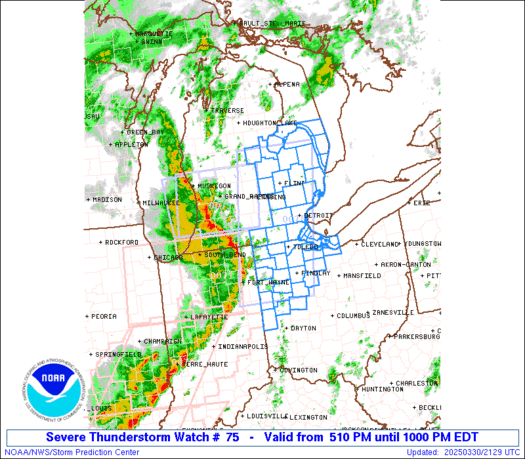
• Welcome to TalkWeather!
    We see you lurking around TalkWeather! Take the extra step and join us today to view attachments, see less ads and maybe even join the discussion.
    CLICK TO JOIN TALKWEATHER

Severe WX Severe Weather Threat 3/26-3/29, 2020

Equus

Member
Messages
3,295
Reaction score
3,380
Location
Jasper, AL
Special Affiliations
  1. SKYWARN® Volunteer
Til 4am; 40/20

ww0075_radar.gif
 

bwalk

Member
Messages
597
Reaction score
291
Location
Prattville, Al
Entire low pressure system is taken on that classic comma look with the comma head centered in the St. Paul, Minnesota area.
 

Equus

Member
Messages
3,295
Reaction score
3,380
Location
Jasper, AL
Special Affiliations
  1. SKYWARN® Volunteer
A middle of the night QLCS spinup whack-a-mole at that. Better grab some caffeine heh
 

Equus

Member
Messages
3,295
Reaction score
3,380
Location
Jasper, AL
Special Affiliations
  1. SKYWARN® Volunteer
Bowing segment headed this way, number of severe warnings have ticked up in the last little while. Hearing distant thunder now. Tornado watch extended til 5am and a few more counties to the east are included in it.

Oh joy, warned for 70mph winds and baseball sized hail. This won't be fun.
 

Equus

Member
Messages
3,295
Reaction score
3,380
Location
Jasper, AL
Special Affiliations
  1. SKYWARN® Volunteer
Lots of lightning and some strong wind gusts but looks like the hail diminished and the remnants of that core passed north of here. Time to finally sleep.
 

warneagle

Member
Messages
3,788
Reaction score
3,381
Location
Arlington, VA
Special Affiliations
  1. SKYWARN® Volunteer
Update: A friend in Jonesboro tells me 22 injured, only two that required hospitalization and none life-threatening. The coronavirus shutdown ironically probably saved a lot of lives.
 
Last edited:

Equus

Member
Messages
3,295
Reaction score
3,380
Location
Jasper, AL
Special Affiliations
  1. SKYWARN® Volunteer
Tim Marshall is out and about in Jonesboro. Going to be an interesting survey.
 

Equus

Member
Messages
3,295
Reaction score
3,380
Location
Jasper, AL
Special Affiliations
  1. SKYWARN® Volunteer
Preliminary rated low end EF3, 140mph. Let the disagreement begin

To be fair most structural damage didn't seem TOO high end, and I'd agree mostly on structural damage alone, but I have never in my life seen anything below a mid EF4 cause vehicle damage anywhere close to what this one did.
 
Last edited:

Kory

Member
Messages
4,928
Reaction score
2,119
Location
Tuscaloosa, Alabama
Preliminary rated low end EF3, 140mph. Let the disagreement begin

To be fair most structural damage didn't seem TOO high end, and I'd agree mostly on structural damage alone, but I have never in my life seen anything below a mid EF4 cause vehicle damage anywhere close to what this one did.
Maybe it wasn’t as strong as it looked. Tuscaloosa is a little bigger than Jonesboro. The tornado *looked* similar in size and strength as the Tuscaloosa tornado. Only about a dozen injuries where as Tuscaloosa had several hundred injured and 52 fatalities.
 

Equus

Member
Messages
3,295
Reaction score
3,380
Location
Jasper, AL
Special Affiliations
  1. SKYWARN® Volunteer
Yeah the lack of fatalities certainly gives credence to a lower intensity, structural damage alone would line up with it as well as only a couple houses were damaged to a more than EF2 level from what I've seen. Not at all surprised really but I wish vehicles were a more widely standardized DI since I've seen photos of multiple cars mangled far beyond structural damage would seem to indicate. Seemed like an extremely narrow core of highest intensity so maybe the strongest core didn't hit anything major?
 

Equus

Member
Messages
3,295
Reaction score
3,380
Location
Jasper, AL
Special Affiliations
  1. SKYWARN® Volunteer
On another note check out the massive swath of wind damage in Tennessee from last night, those bowing QLCS segments probably did more damage than the early day MDT and ENH combined

yesterday.png

1630z verification not including the Tennessee swaths (occuring after verification cutoff times)

day1otlk_v_20200328_1630.gif
 
Last edited:

buckeye05

Member
Messages
3,158
Reaction score
4,712
Location
Colorado
The severely mangled vehicle that was shown was a mail truck, not a typical vehicle. Obviously constructed differently, and lots of non-structural metal paneling to rip apart. Lots of surface area too.

I don’t agree with Tim Marshall’s reputation of being overly conservative. He’s very objective and middle of the road if you actually take the time to read his surveys. Also I never saw any clear cut EF4 damage in any of the photos or videos posted. I feel like a lot of the EF4 speculation is a result of how the tornado itself looked. Just because it looked like Tuscaloosa, doesn’t mean it was capable of that caliber of damage.
 
Last edited:

Equus

Member
Messages
3,295
Reaction score
3,380
Location
Jasper, AL
Special Affiliations
  1. SKYWARN® Volunteer
My only real argument was vehicle damage and claims of unusually high TDS height, so if no more 'standard' vehicles were thrashed in that manner then the structural damage lines up pretty well with the rating. I'm kinda surprised there wasn't worse structural damage but this seemed even narrower than Cookeville, so while I'm sure there was probably low EF4 potential somewhere along its path I doubt it hit anything with that core at its peak. I'm way more impressed with how fast it went from wall cloud to Tuscaloosa 2.0 than the damage dealt anyway lol

Also unlike Cookeville, everyone survived in the homes that were hit, and usually in EF4 your chance of survival in even a well built frame home heads rapidly towards nil... I suspect Covid-19 actually SAVED some lives as the commercial district seemed harder hit and most non essential retail businesses hardest hit were apparently closed due to virus quarantines etc
 
Back
Top