I mean given the forbidden date comparisons, it’s only natural considering how it’s performed so far…. I’m very happy about thatTo summarize, let’s not comment on the event performance until after it’s over.
Done and done.
Navigation
Install the app
How to install the app on iOS
Follow along with the video below to see how to install our site as a web app on your home screen.
Note: This feature may not be available in some browsers.
More options
-
Welcome to TalkWeather! We see you lurking around TalkWeather! Take the extra step and join us today to view attachments, see less ads and maybe even join the discussion. CLICK TO JOIN TALKWEATHER -
Current Tropical Systems Melissa
You are using an out of date browser. It may not display this or other websites correctly.
You should upgrade or use an alternative browser.
You should upgrade or use an alternative browser.
Severe WX Severe Weather Threat 3/14-3/16
- Thread starter Bulkshear
- Start date
RollTide18
Member
Really interested to see what the line does as it moves south and East of 20/59 where there hasn’t been much rain and the sun was out most of the day.
As bad as it’s been today, at least the storms have been a bit messy and linear as opposed to very spread out (please correct me if I’m wrong).
Still, event is far from over and I think things will ramp up as the line fully moves into Alabama.
As bad as it’s been today, at least the storms have been a bit messy and linear as opposed to very spread out (please correct me if I’m wrong).
Still, event is far from over and I think things will ramp up as the line fully moves into Alabama.
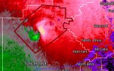
Tuscaloosa cell wrapping up some
Snipeslayer
Member
Novice question: if I'm following the hour by hour stp and supercell trending it's reducing the overall involvement for Atlanta. Is that just increasing accuracy closer, or not factoring in accurate intensity in proximity to the storm system itself?Lookslike Atlanta, later tonight, could be extremely violent.
It appears is moves more linear with slightly less super cellular development in front if I'm seeing it correctly. My apologies if it wasn't a great question, still trying to learn.
SilentShadow87
Member
Again, an event not being a super outbreak does NOT equal being a Forecasted Convective Amplification Deficiency. We've had 3-4 potentially violent tornadoes today. That justifies a high risk. If anything the placement was maybe a bit too far east, but still.
CheeselandSkies
Member
The Tuscaloosa storm has essentially split. The original circulation that spawned the TDS is the left mover and will probably die off as it has its inflow cut off. The main supercell is developing another mesocylone and inflow is ramping up significantly.
Looked like a pretty classic occlusion/cycle. The old circulation apparently produced right as it occluded, curling off to the left while the "main" meso closer to Coker looked more prominent on the velocity product, but wasn't actively producing.
TornadoFan
Member
New supercell south of Hammond, LA?
MikeP
Member
Great image.Cloud heights on the Tuscaloosa supercell have increased as the updraft strengthens. View attachment 36251
A tornado maybe imminent from the Tuscaloosa cell.
TornadoFan
Member
Brad Arnold reporting a bowl funnel in front of him.
US_Highway15
Member
At this point I would get the parameters from the SPC Mesoscale page vs the HRRROnce again, new HRRR run, new CAPE increases.
Here is the 19z simulation of 20z
View attachment 36252
Here is 20z actual. Getting into the 4000s now.
View attachment 36253
We're not seeing tornadoes though, so maybe i'm just misinterpreting it.
I think it may take off, nothing to ingest after the last little bit of convection that it did.AL storm getting ready to drop again.
AJS
Member
MikeP
Member
Hope folks in Jasper are on their toes....


