tennessee storm chaser
Member
- Messages
- 1,871
- Reaction score
- 4,275
- Location
- jackson tennessee
- Special Affiliations
- SKYWARN® Volunteer
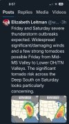
Look for a 15 percent hatched be added in location be honest later outlook. Friday nightWell this is a hell of a thing to wake up to. I’m still concerned we’re downplaying the tornado threat for tomorrow night in KY/TN, hopefully the CAMS provide some clarity on that.