Updated Jackson AFD:
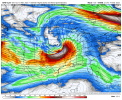
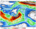
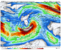
Late week through the weekend: By far, it appears the most impactful weather this week will occur in the late Friday through Saturday time frame with two distinct rounds of severe weather expected. A powerful shortwave trough will traverse the Plains and move into the MS Valley Friday into Friday night. As this happens, strong cyclogensis will bring substantial height falls into the area with and support thunderstorm development over northwest portions of the area, especially by late Friday into Friday evening and overnight (This being "Round 1"). High levels of instability and wind shear will support severe supercell development capable of tornadoes, damaging winds, and large hail. Uncertainty exists with how far southeast the threat will extend through Fri night as initially there will be a strong capping
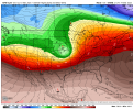
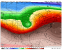
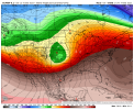
inversion that limits tstm potential. So while the current graphic messaging for the Friday night period includes the entire area with at least a slight severe risk, the southeast portions of the area, particularly the Pine Belt region, will most likely not get any storms until Saturday ("Round 2") when the next wave of convection develops. The bulk of the forecast area should be impacted by severe weather and perhaps flooding threats Saturday. Some guidance indicate the impacts will be felt most over eastern MS, while others hold the second wave back some and affect more of the area. These details will get ironed out as we get closer, but for now, would generally expect a high impact severe weather/heavy rainfall event Saturday as there will continue to be a considerable amount of instability/deep layer shear and strong ascent. The difference with Saturday is that there will be more forcing and less capping, so there may be more numerous storms and more severe coverage with not quite as high of a ceiling for intensity, but would not want to make that determination this far in advance. Depending on how much the second round hangs back, training of storms and heavy rainfall be a greater concern. Have held off on putting out a heavy rainfall graphic with most focus on the severe weather, but this will be something to monitor along with gradient wind impacts as well. The storms could linger into Saturday night before strong cold advection brings in drier and cooler air for Sunday.


.gif")


