
I’ll reread Dr Corfidi’s paper and seeI’ve never heard of this. I would actually like to know the answer to this question. Also just saying that this does seem to have a pretty high ceiling
Navigation
Install the app
How to install the app on iOS
Follow along with the video below to see how to install our site as a web app on your home screen.
Note: This feature may not be available in some browsers.
More options
-
Welcome to TalkWeather! We see you lurking around TalkWeather! Take the extra step and join us today to view attachments, see less ads and maybe even join the discussion. CLICK TO JOIN TALKWEATHER
You are using an out of date browser. It may not display this or other websites correctly.
You should upgrade or use an alternative browser.
You should upgrade or use an alternative browser.
Severe WX Severe Weather Threat 3/14-3/16
- Thread starter Bulkshear
- Start date
18z GFS is a big OOF for MS/AL wow.
Insane.
Insane.
tennessee storm chaser
Member
- Messages
- 1,871
- Reaction score
- 4,275
- Location
- jackson tennessee
- Special Affiliations
- SKYWARN® Volunteer
Western half tn also bad Friday night18z GFS is a big OOF for MS/AL wow
tennessee storm chaser
Member
- Messages
- 1,871
- Reaction score
- 4,275
- Location
- jackson tennessee
- Special Affiliations
- SKYWARN® Volunteer
Cape values creeping higher even on this run
Secondary low over Memphis. Screams bad for Alabama and Mississippi. Going to dive in on the model in a secondWestern half tn also bad Friday night
“The Kansas surface low began to fill slightly as it tracked slowly northeastward to near Burlington, Iowa, by 0000 UTC Thursday, 4 April”I’ll reread Dr Corfidi’s paper and see
Above is from Corfidi’s paper.
So by around 7 PM EST the low was filling gradually as it tracked into Iowa. By that point though the majority of supercells had already fired and convective band two’s tornados were in central And southern KY, TN, and the Alabama event were underway.
tennessee storm chaser
Member
- Messages
- 1,871
- Reaction score
- 4,275
- Location
- jackson tennessee
- Special Affiliations
- SKYWARN® Volunteer
That would even back winds more over parts tn alsoSecondary low over Memphis. Screams bad for Alabama and Mississippi. Going to dive in on the model in a second
- Thread starter
- #168
Bulkshear
Member
I just saw that 2nd low. 994 to 989. Good Lord!Secondary low over Memphis. Screams bad for Alabama and Mississippi. Going to dive in on the model in a second
- Thread starter
- #170
Bulkshear
Member
This would impact TN in a bad way as well as this lifts northward correct?I just saw that 2nd low. 994 to 989. Good Lord!
It wouldThis would impact TN in a bad way as well as this lifts northward correct?
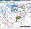
Gotta post these two shots. My gosh the supercell composite is incredibly high. That secondary low is not good for Mississippi/Alabama/Georgia.I just saw that 2nd low. 994 to 989. Good Lord!


tennessee storm chaser
Member
- Messages
- 1,871
- Reaction score
- 4,275
- Location
- jackson tennessee
- Special Affiliations
- SKYWARN® Volunteer
Bad badThis would impact TN in a bad way as well as this lifts northward correct?
- Thread starter
- #174
Bulkshear
Member
This looks like it develops a secondary low so this won’t matter“The Kansas surface low began to fill slightly as it tracked slowly northeastward to near Burlington, Iowa, by 0000 UTC Thursday, 4 April”
Above is from Corfidi’s paper.
So by around 7 PM EST the low was filling gradually as it tracked into Iowa. By that point though the majority of supercells had already fired and convective band two’s tornados were in central And southern KY, TN, and the Alabama event were underway.
tennessee storm chaser
Member
- Messages
- 1,871
- Reaction score
- 4,275
- Location
- jackson tennessee
- Special Affiliations
- SKYWARN® Volunteer
If the euro picks this up. Good lord !
- Thread starter
- #176
Bulkshear
Member
Yes… This would have outbreak all over it if it plays outThat would even back winds more over parts tn also
Lol, this is one model run, but man that took a unexpected turn to me, you really don't want a secondary low taking that path if you live in Mississippi or Alabama.
- Thread starter
- #178
Bulkshear
Member
I’m curious. I pointed this out to Fred a couple days ago. The GFS was showing this as a solution. I don’t know if Fred’s opinion would now change, especially if the euro jumps on board.If the euro picks this up. Good lord !
- Thread starter
- #179
Bulkshear
Member
Or up in TN eitherLol, this is one model run, but man that took an unexpected turn to me, you really don't want a secondary low taking that path if you live in Mississippi or Alabama.
Correct for Saturday, but not necessarily for Friday.This looks like it develops a secondary low so this won’t matter