
Navigation
Install the app
How to install the app on iOS
Follow along with the video below to see how to install our site as a web app on your home screen.
Note: This feature may not be available in some browsers.
More options
-
Welcome to TalkWeather! We see you lurking around TalkWeather! Take the extra step and join us today to view attachments, see less ads and maybe even join the discussion. CLICK TO JOIN TALKWEATHER
You are using an out of date browser. It may not display this or other websites correctly.
You should upgrade or use an alternative browser.
You should upgrade or use an alternative browser.
Severe WX Severe Weather Threat 3/14-3/16
- Thread starter Bulkshear
- Start date
They’re actually similar to how the HRRR depicted. More of a broken line look. It’s definitely not a straight up squall lineNo matter if they were discrete or not; they were still going to produce lots of tornadoes. The event tonight hasn’t even tapped into it’s full potential just yet.
- Messages
- 751
- Reaction score
- 2,465
- Location
- Mississippi State University
- Special Affiliations
- SKYWARN® Volunteer
We'd have a MD by now if we were going high at the next update.Any chance this PDS watch is indicative of a late night upgrade to high risk?
Doesn't really matter what the colors on the screen are, we are watching the event unfold in real time.
Evan
Member
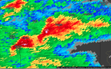
View attachment 35693That’s side lobe contamination.
Referring to the presentation from about 10-15 minutes before your screenshot.
That’s an extremely dangerous looking picture. Just knowing the environment out aheadThis is certainly a look. Like @andyhb pointed out, a very volatile environment ahead of these storms as they progress to the east. Tornado outbreak appears increasingly likely.
View attachment 35695
Teche
Member
tornado examiner
Member
The 23z hrrr for tomorrow looks nearly identical to April 27 2011 in many ways…
AJS
Member
Do you happen to have a picture of the run? It would be interesting to see.The 23z hrrr for tomorrow looks nearly identical to April 27 2011 in many ways…
- Messages
- 751
- Reaction score
- 2,465
- Location
- Mississippi State University
- Special Affiliations
- SKYWARN® Volunteer
Can you post a pic from the 23Z run next to a radar pic from 4/27? If it looks nearly identical I'd like to see the comparison instead of just saying that and leaving out the context.The 23z hrrr for tomorrow looks nearly identical to April 27 2011 in many ways…
Cood101
Member
Per Ryan Hall's stream, Firefighters confirming Tornado spotted coming into Rolla, MO.
TornadoFan
Member
Tornado reported moving into Rolla, MO
Evan
Member
Andy's already pointed out how primed the environment is around KLZK. We've got a train of cells lined up just waiting to saunter right into it. So far the HRRR has been pretty spot on with what it has forecasted.
N0mz
Member
Tornado confirmed down in Rolla
SmokeEater
Member
TOG heading into Rolla, MO.
jiharris0220
Member
Lead supercell in Missouri is entering a radar hole, tornado is still on the ground though according to scanner.
tornado examiner
Member
This is insane. Like from the early stages of this run it looks nearly identical
Jetstream
Member
Firefighters reporting tornado on the ground near Rolla Mo.
Rolla is fairly decent size right?
Kds86z
Member
20kRolla is fairly decent size right?
Western_KS_Wx
Member
Very nasty velocity couplet moving into Rolla, Missouri. As others have pointed out, firefighters have reported a tornado on the ground.