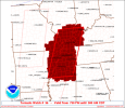
That is one big PDS watch. You're included @JPWX

URGENT - IMMEDIATE BROADCAST REQUESTED
Tornado Watch Number 36
NWS Storm Prediction Center Norman OK
730 PM CDT Fri Mar 14 2025
The NWS Storm Prediction Center has issued a
* Tornado Watch for portions of
Northeast Arkansas
Southern Illinois
Far Southwest Indiana
Western Kentucky
Southeast Missouri
Northern Mississippi
Western Tennessee
* Effective this Friday night and Saturday morning from 730 PM
until 300 AM CDT.
...THIS IS A PARTICULARLY DANGEROUS SITUATION...
* Primary threats include...
Several tornadoes and a few intense tornadoes likely
Widespread damaging winds and scattered significant gusts to 80
mph likely
Scattered large hail and isolated very large hail events to 2.5
inches in diameter likely
SUMMARY...Severe thunderstorms are expected to develop across the
watch area over the next several hours. Environmental conditions are
very favorable for supercells capable of all severe hazards,
including very large hail (i.e. greater than 2" in diameter) and
strong (EF2+) tornadoes. If storms can remain discrete, potential
exists for a few long-track tornadoes.
The tornado watch area is approximately along and 75 statute miles
east and west of a line from 40 miles west northwest of Evansville
IN to 25 miles southwest of Oxford MS. For a complete depiction of
the watch see the associated watch outline update (WOUS64 KWNS
WOU6).
PRECAUTIONARY/PREPAREDNESS ACTIONS...
REMEMBER...A Tornado Watch means conditions are favorable for
tornadoes and severe thunderstorms in and close to the watch
area. Persons in these areas should be on the lookout for
threatening weather conditions and listen for later statements
and possible warnings.


