
Navigation
Install the app
How to install the app on iOS
Follow along with the video below to see how to install our site as a web app on your home screen.
Note: This feature may not be available in some browsers.
More options
-
Welcome to TalkWeather! We see you lurking around TalkWeather! Take the extra step and join us today to view attachments, see less ads and maybe even join the discussion. CLICK TO JOIN TALKWEATHER
You are using an out of date browser. It may not display this or other websites correctly.
You should upgrade or use an alternative browser.
You should upgrade or use an alternative browser.
Severe Weather Threat 3/13-3/15/2024
- Thread starter MattPetrulli
- Start date

PDS
Velocity radar-hole now. TORP.

Severe Weather Statement
National Weather Service Wilmington OH
712 PM EDT Thu Mar 14 2024
OHC011-142330-
/O.CON.KILN.TO.W.0012.000000T0000Z-240314T2330Z/
Auglaize OH-
712 PM EDT Thu Mar 14 2024
...A TORNADO WARNING REMAINS IN EFFECT UNTIL 730 PM EDT FOR AUGLAIZE
COUNTY...
At 711 PM EDT, a confirmed large and extremely dangerous tornado was
located near St. Marys, moving east at 45 mph.
This is a PARTICULARLY DANGEROUS SITUATION. TAKE COVER NOW!
HAZARD...Damaging tornado.
SOURCE...Emergency management confirmed tornado. Auglaize County EMA
reported a tornado producing damage.
IMPACT...You are in a life-threatening situation. Flying debris may
be deadly to those caught without shelter. Mobile homes
will be destroyed. Considerable damage to homes,
businesses, and vehicles is likely and complete destruction
is possible.
Locations impacted include...
Wapakoneta, St. Marys, Fort Shawnee, Cridersville, New Knoxville,
Moulton, Buckland, Fryburg, Kossuth, State Route 116 at State Route
197, and Bulkhead.
This includes I-75 in Ohio between mile markers 106 and 118.
PRECAUTIONARY/PREPAREDNESS ACTIONS...
To repeat, a large, extremely dangerous and potentially deadly
tornado is on the ground. To protect your life, TAKE COVER NOW! Move
to a basement or an interior room on the lowest floor of a sturdy
building. Avoid windows. If you are outdoors, in a mobile home, or in
a vehicle, move to the closest substantial shelter and protect
yourself from flying debris.
To report severe weather, go to our website at weather.gov/iln and
submit your report via social media, when you can do so safely.
&&
LAT...LON 4066 8422 4066 8411 4064 8411 4064 8410
4048 8408 4048 8446 4067 8445 4069 8430
4069 8422
TIME...MOT...LOC 2311Z 272DEG 37KT 4056 8442
TORNADO...OBSERVED
TORNADO DAMAGE THREAT...CONSIDERABLE
MAX HAIL SIZE...1.00 IN
$$
Hatzos
I remember the last time that happened. Yikes.Velocity radar-hole now. TORP.
View attachment 24285

Is that twin siggies?
No cc drop or debris ball but tag says observed?
No cc drop or debris ball but tag says observed?
cincywx
Member
used to go to wapakoneta once a year as a kid, bizarre that it's about to be split by two possible tors
atrainguy
Member
Hard to see any CC drop due to noise + beam distance, but I don't doubt there's something down.Is that twin siggies?
No cc drop or debris ball but tag says observed?
atrainguy
Member
cincywx
Member
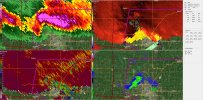
The wapokenta couplet looks the most impressive so far right now
LARGE TORNADO on the ground! Big debris ball
LARGE TORNADO on the ground! Big debris ball

cincywx
Member
that is far from the radar site as well. wow.
Shiiiii! Dual intense couplets with big debris ball!
*Either that or just a big couplet with multiple velocity maxes on the southern and northern side of the large couplet
*Either that or just a big couplet with multiple velocity maxes on the southern and northern side of the large couplet
atrainguy
Member
Warning is "Observed" now.
TH2002
Member
- Messages
- 4,974
- Reaction score
- 11,116
- Location
- California, United States
- Special Affiliations
- SKYWARN® Volunteer
Warning updated to observed.
warneagle
Member
I can't believe there's not a radar in Toledo.