• Welcome to TalkWeather!
    We see you lurking around TalkWeather! Take the extra step and join us today to view attachments, see less ads and maybe even join the discussion.
    CLICK TO JOIN TALKWEATHER

Severe Weather Thread - 6/17/26 - 6/18/26

Messages
1,548
Reaction score
6,960
Location
Ireland
Right. I know SPC hasn't outlined a area and you can call this premature if you want, i understand if so. But I think there's been enough trends on ensembles and enough consistency on deterministics to pull this. Many runs have shown a high end, anomalous parameter space for portions of Missouri into Illinois (go figure, it's 2026) and haven't really backed down on this threat at all.

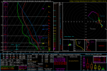
I expect SPC to pull a 15% sometime tomorrow. Because I'm not sure that this cold front on Monday will big time affect this event. Maybe less instability than modeled but for the worth the kinematics are there. Uncertainty remains but this is what you're dealing with. Sounding taken from W MO around the LLJ peak. Maybe 2026 goes again with its classic red herrings, but maybe we go again next week. Remains to be seen. Watch this closely.

2026061218_GFS_126_38.97,-93.27_severe_ml.pngScreenshot_2026-06-12-23-21-04-637.jpegScreenshot_2026-06-12-23-20-43-101.jpeg
 
Writeups I did for New England:

Stormnet ringing bells for us Thursday. For those unaware, Stormnet is a new AI tool for SVWX forecasting that came out this year and has performed exceptionally well. Green is about equivalent to an SPC slight or enhanced, so this is quite a strong signal for d5. I know some may hesitate due to relatively modest forecast EMLs, but globals tend to underestimate thermos, and with the forecast shear (60-70+ EBWD and 300+ 3k SRH), I wouldn't want to count anything out. We await the king NAM.

and Mid Atlantic:

Since I'm back home in Boston, I've mostly been following our weather, but I wanted to stop by here. Obviously, insanely potent jet for this time of year, with 100+ kt on Wednesday over the Midwest and nearly 100kt as it takes on a negative tilt on Thursday over NE, both per 00z euro. The GooFuS solution favors you all with the trough swinging down a little bit more and overspreading the region with 40-50kt flow, which is good for this time of year. It should be noted that with these super-fast (speed and translation) punching jets, you don't need to be right in the centroid to see good storms. Deep-layer shear should be pretty good due to the strength of the jet, although it remains to be seen whether the LLJ and associated SRH will reach down to MA. Attached is a model sounding at BWI at 18z from the 00z GFS. 41 EBWD supportive of supercells, but, as you can see, it's mostly speed shear with no real turning with height due to a very modest 850mb jet. CAPE is skinny on this sounding in particular, but I wouldn't worry, as many others were 1000-1500+, and globals tend to underestimate thermos anyways. We will have to wait for the SVWX king, the NAM, to bring us the goods.

over on americanwx
 
Safe to say, a potentially dangerous day with strong to intense tornadoes in Central MO. GFS suggests discrete development in a dangerous kinematic environment. Further east, I'm having doubts about how much CAPE arrives for IL/IN.
 
Back
Top