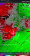
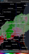
So far, based on radar presentation.
1 sig tor in Iowa.
2 sig tor in Illinois
1 sig, tor and 1 vi torn in IN
So that’s 4 sig tors and 1 vi tor.
So still on the lower end of verification and no long trackers, but far from a bust.
The surface inversion that done in tornadogenesis earlier in the evening had largely went away due to sufficient mixing from persistent warm air advection from the intensifying LLJ. This allowed supercells to finally become surface based and tap into that high streamwise vorticity.
Obviously though, it didn’t go away completely, as the air is still pretty dry at the LFC, which most certainly is causing these cells to become outflow dominant, which again thwarted long trackers.
Overall though, this event verified, barely.
Definitely was unwise to call the event off, although to my and others defense, there was no reason to suggest otherwise as both the dryline completely failed to produce tornadoes and the boundary riders didn’t start to produce until after dark, which absolutely none of the cams (specifically today) were forecasting that scenario.
View attachment 53648