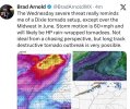
Like, I cannot stress enough how anomalous this environment would be. I don’t know if I’ve ever seen a potential outbreak environment in the Midwest with STP values this high. Hell, we almost never see it this high in higher-end plain events. Even in Dixie Alley, you only see maybe 3-4 events a decade with this kind of STP in-play.
Add in that we’re talking about storm motions that you only ever see in cold season events or exceptional outbreak days like 5/10/2010 or 4/27/2011 and you’ve got an outlier in every sense of the word.