
Navigation
Install the app
How to install the app on iOS
Follow along with the video below to see how to install our site as a web app on your home screen.
Note: This feature may not be available in some browsers.
More options
-
Welcome to TalkWeather! We see you lurking around TalkWeather! Take the extra step and join us today to view attachments, see less ads and maybe even join the discussion. CLICK TO JOIN TALKWEATHER
You are using an out of date browser. It may not display this or other websites correctly.
You should upgrade or use an alternative browser.
You should upgrade or use an alternative browser.
Severe WX Severe Weather Thread - 6/15/26 - 6/18/26
- Thread starter WeathermanLeprechaun
- Start date
jiharris0220
Member
Who’s ready for another midwestern event? It’s only been the tenth thousandth time, anyone?


Kds86z
Member
This day has had a strong signal on the GEFS ensemble SCP for several days now too.Who’s ready for another midwestern event? It’s only been the tenth thousandth time, anyone?
View attachment 53700View attachment 53701
Kds86z
Member
Who’s
starting the thread? Lol. Also Saturday in NE and KSThis day has had a strong signal on the GEFS ensemble SCP for several days now too.
Kds86z
Member
Kds86z
Member
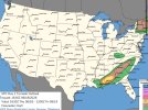
Latest D1 has expanded the tornado risk into Georgia and the Carolinas. Damaging winds are also possible.

Day 1 Convective Outlook
NWS Storm Prediction Center Norman OK
1116 AM CDT Thu Jun 18 2026
Valid 181630Z - 191200Z
...THERE IS A SLIGHT RISK OF SEVERE THUNDERSTORMS ACROSS PARTS OF
NEW ENGLAND...THE MID-ATLANTIC REGION...AND FROM THE GULF COAST
STATE INTO THE CAROLINAS....
...SUMMARY...
Isolated to scattered severe thunderstorms are expected from
Kentucky and the central Appalachians to the Mid-Atlantic, with
primarily damaging wind gusts or marginal hail. Scattered severe
storms are possible from upstate New York into New England, with
damaging wind gusts and tornado potential. A few tornadoes may also
occur over parts of the middle Gulf Coast states, and scattered
storms may produce gusty winds or marginal hail from Oklahoma into
western North Texas.
...NY/New England...
A fast-moving low-topped squall line is tracking eastward across NY.
Low and mid level wind fields in this region are very strong,
contributing to occasional bowing structures and QLCS mesocyclones.
This activity will spread into VT/NH through the afternoon with a
continued risk of damaging winds and isolated tornadoes. Confidence
in severe storms farther south into southern New England is lower,
but at least isolated strong/damaging wind gusts are possible.
...KY into Mid Atlantic...
A remnant outflow boundary from overnight storms extends across KY
into southern VA. Strong heating along and south of the boundary
will likely result in renewed convection this afternoon, in a zone
of moderate westerly flow aloft and CAPE values around 2000 J/kg. A
few severe storms are expected in this corridor, with activity
moving into northern NC later today. Damaging winds are the main
risk.
...Gulf Coast into Carolinas...
The remnant circulation of Arthur is becoming more progressive with
time, and is accelerating eastward. As this occurs, the zone of
relatively strong southerly low-level winds will also shift across
AL into GA and eventually SC/NC tonight. Ample low-level moisture
and high theta-e values will coincide with the region of strong
shear, and CAM solutions suggest clusters of thunderstorms in this
area as well. This suggests at least some risk of damaging wind
gusts and tornadoes through the afternoon and night as the system
moves northeastward.
...TX/OK...
Scattered thunderstorms will occasional hail risk will slowly
diminish across northern OK this afternoon. Later today, new
thunderstorms are expected to develop in a hot and very unstable air
mass in vicinity of the surface low near ABI/SJT. These slow-moving
storms will have some damaging wind and hail risk through the
evening.
..Hart/Chalmers.. 06/18/2026
- Thread starter
- #1,210
WeathermanLeprechaun
Member
For one, i ain't starting a thread after what happened last night LOL
Should be a secondary flare up to tornado potential in south Alabama through the afternoon
Kds86z
Member
From earlier
Well it's CJ so who knows with that clown
Jacob Aden
Member
I’m in Charlotte for work, I’m not looking forward to the overnight severe weather.
Kds86z
Member
OHWX97
Member
Wanted to clarify that this was the one in Dearborn County, Indiana, near Aurora. Clearly a very significant tornado.damage pic from the Indiana big debris ball.
jiharris0220
Member
Wanted to clarify that this was the one in Dearborn County, Indiana, near Aurora. Clearly a very significant tornado.
The structure is slabbed but the trees all around it are virtually pristine, obviously, the construction practices here weren’t up to par to say the very least.
KakashiHatake2000
Member
I know tor threat was already posted but also flooding could be a concern with a high risk of excessive rainfall