Navigation
Install the app
How to install the app on iOS
Follow along with the video below to see how to install our site as a web app on your home screen.
Note: This feature may not be available in some browsers.
More options
-
Welcome to TalkWeather! We see you lurking around TalkWeather! Take the extra step and join us today to view attachments, see less ads and maybe even join the discussion. CLICK TO JOIN TALKWEATHER
You are using an out of date browser. It may not display this or other websites correctly.
You should upgrade or use an alternative browser.
You should upgrade or use an alternative browser.
Severe weather all hazards threat for today wed 10/21 and tomorrow thurs 10/22 2026
- Thread starter KakashiHatake2000
- Start date
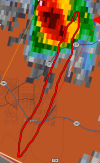
When I posted this it looked like a classic supercell in my defense.Swift tail junction storm is going to do it.
- Thread starter
- #65

KakashiHatake2000
Member
Looks like multiple could be rotating possible still insane
Seems like there is a lot more activity now with much less lethargic supercells.Looks like multiple could be rotating possible still insane
Kds86z
Member
akt1985
Member
Since the sun has gone down, the earlier Tornado Watch in Arizona was replaced with a Severe Thunderstorm Watch.
It's been downgraded for a bit, dunno if that was a good call given current radar presentation.Since the sun has gone down, the earlier Tornado Watch in Arizona was replaced with a Severe Thunderstorm Watch.

N0mz
Member
Wrote something up in the main thread before realizing this one existed: https://talkweather.com/threads/severe-weather-2026.2432/post-215120
I do see a possibly more favorable air mass with much warmer temperatures was shunted off to the SE.

Possibly, this was caused by terrain not allowing a typical southeasterly mass response, allowing cooler air to remain over the risk area. This terrain effect is why you see the gap in violent tornadoes from SE KY through WV and W VA up to Maryland, as the Appalachians typically prevent any southeasterly mass response from improving surface conditions. Meanwhile, the opposite occurs around OH and W PA, where historically there have been a few more violent tornadoes (although many are from a single outbreak) because the very flat terrain in OH, N KY, and IN allows for improved Gulf moisture fetch, even though this area is a bit further north than WV.

A couple of caveats: I am late to the party, so, as much as I try to avoid it, I am hindcasting a bit. Also, while there were warmer temperatures to the south, they had much larger t-d spreads, so they could have hurt more than they helped. There also wasn't a super consistent surface SE flow, although it may have been a little more evident at 925, as seen here.

Finally, I'm not super knowledgeable about hailers in general, especially with terrain effects. Orographically stretching the meso might hurt hailers as it forces the meso out of its "natural" and probably most stable state, although I'm really just guessing.
I do see a possibly more favorable air mass with much warmer temperatures was shunted off to the SE.
Possibly, this was caused by terrain not allowing a typical southeasterly mass response, allowing cooler air to remain over the risk area. This terrain effect is why you see the gap in violent tornadoes from SE KY through WV and W VA up to Maryland, as the Appalachians typically prevent any southeasterly mass response from improving surface conditions. Meanwhile, the opposite occurs around OH and W PA, where historically there have been a few more violent tornadoes (although many are from a single outbreak) because the very flat terrain in OH, N KY, and IN allows for improved Gulf moisture fetch, even though this area is a bit further north than WV.
A couple of caveats: I am late to the party, so, as much as I try to avoid it, I am hindcasting a bit. Also, while there were warmer temperatures to the south, they had much larger t-d spreads, so they could have hurt more than they helped. There also wasn't a super consistent surface SE flow, although it may have been a little more evident at 925, as seen here.
Finally, I'm not super knowledgeable about hailers in general, especially with terrain effects. Orographically stretching the meso might hurt hailers as it forces the meso out of its "natural" and probably most stable state, although I'm really just guessing.
Last edited:

joshoctober16
Member
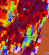
over a populated area.
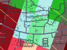
joshoctober16
Member
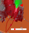
path of the tornado , looks like it went into the whole town from bottom to top.
joshoctober16
Member
tornado remenent.
and likely path of the tornado.