TornadoFan
Member

Follow along with the video below to see how to install our site as a web app on your home screen.
Note: This feature may not be available in some browsers.
I had that exact same thought earlier. If you imagine a Mayfield like configuration directly anchored to the warm front, you can see how something like Tri State could last as long as it did.Not often you see a day where there was a significant wind, hail, and tornado threat that pretty much all verified to some degree. Not saying it's anywhere near the same level, but this storm in northern Indiana is similar to the Tri-State supercell in some ways. Just absolutely going bonkers on the warm front.
This is genuinely incredible to watch from a meteorological perspective. There hasn't been a cell pumping out intense tornadoes this consistently in a LONG while. Very pristine nocturnal environment and when you juice that with the WF, it's a tornado machine.This cell is feeding off a pretty high end environment. No nudgers required. I know Nixon’s research shows purely discrete supercells often don’t produce tornados, when an environment is as overwhelming and pristine as this, it doesn’t matter.

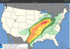
Driven by 5% CIG1 tornado I believe, it was 2% before. Also, TOR-E!Enhanced risk now covers from the us-Mexico border all the way to Michigan. This is completely insane.
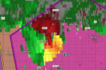
Be careful when saying things like this. This isn't a large tornado. It's a a outflow dominant storm and the clutter plus cc is messing you up.